Chimala geodata
Chimala (Mbeya) is a populated place; located in Tanzania in Africa/Dar_es_Salaam (GMT+3) time zone. With population of 24,817 people, there are 86 cities with bigger population in this country. Compared to other cities in Tanzania, 79.7% of cities are located further ↑North; 63.6% of cities are located further →East and 51.4% of cities have lower elevation than Chimala. Note1


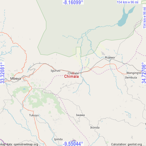
Chimala GPS coordinates[2]
8° 51' 22.932" South, 34° 1' 26.148" East
| Map corner | latitude | longitude |
|---|---|---|
| Upper-left | -8.16099°, | 33.32081° |
| Center: | -8.85637°, | 34.02393° |
| Lower-right: | -9.55044°, | 34.72706° |
| Map W x H: | 154.5×154.5 km | = 96×96mi |
| max Lat: | -1.14389° ⇑79.7% North |
| Chimala: | -8.85637° |
| min Lat: | ⇓20.3% South -11.36667° |
| min Long | Chimala | max Long |
| 29.62667° | 34.02393° | 40.33333° |
| W 36.4%⇐ | ⇒63.6% E |
Elevation
Elevation of Chimala is 1143 m = 3750 ft, and this is 200.2 m = 657 ft above average elevation for this country.
| Max E: |
2377 m = 7799 ft | 48.6% |
| Chimala | 1143 m 3750 ft | |
| Avg. | 942.8 m = 3093 ft | |
Min E: |
0 m = 0 ft | 51.4% |
See also: Tanzania elevation on elevation.city.
Geographical zone
Chimala is located in South Torrid zone (between Equator and Tropic of Capricorn). Distance of Equator is 984.7 km =611.9 mi to North.| Distance of | km | miles | from Chimala |
|---|---|---|---|
| Equator | 984.7 | 611.9 | to North |
| Tropic Capricorn | 1621.2 | 1007.4 | to South |
| Antarctic Circle | 6416.4 | 3987 | to South |
| South Pole | 9022.3 | 5606.2 | to South |


Nearby cities:
15 places around Chimala: (largest is in red/bold)
• Igurusi
19.1 km =11.9 mi,  272°
272°
• Ilembo
82.8 km =51.4 mi,  238°
238°
• Ilembula
61.6 km =38.3 mi,  94°
94°
• Ipinda
71 km =44.1 mi,  191°
191°
• Kandete
40.9 km =25.4 mi,  216°
216°
• Katumba
61.3 km =38.1 mi,  226°
226°
• Kiwira
63.6 km =39.5 mi, 236°
• Kyela
83.1 km =51.6 mi, 193°
• Masoko
61 km =37.9 mi,  209°
209°
• Matamba
15.5 km =9.6 mi,  204°
204°
• Mbeya
63.2 km =39.3 mi, 265°
• Mwaya
77.6 km =48.2 mi, 186°
• Rujewa
43.2 km =26.8 mi,  66°
66°
• Tukuyu
60 km =37.3 mi, 223°
• Ulenje
38.4 km =23.9 mi,  257°
257°
Sources, notices
• [Note1] Compared only with cities in Tanzania existing in our database
• [Src1] Map data: © OpenStreetMap contributors (CC-BY-SA)
• [Src2] Other city data from geonames.org with taken over terms of usage.
• [Src3] Geographical zone / Annual Mean Temperature by Robert A. Rohde @ Wikipedia
