Musoma geodata
Musoma (Mara) is a seat of a first-order administrative division; located in Tanzania in Africa/Dar_es_Salaam (GMT+3) time zone. With population of 121,119 people, there are 12 cities with bigger population in this country. Compared to other cities in Tanzania, 97.6% of cities are located further ↓South; 69.6% of cities are located further →East and 52.4% of cities have lower elevation than Musoma. Note1


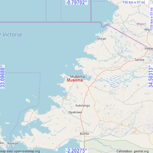
Musoma GPS coordinates[2]
1° 30' 0" South, 33° 48' 0" East
| Map corner | latitude | longitude |
|---|---|---|
| Upper-left | -0.79702°, | 33.09688° |
| Center: | -1.5°, | 33.8° |
| Lower-right: | -2.20275°, | 34.50313° |
| Map W x H: | 156.3×156.3 km | = 97.1×97.1mi |
| max Lat: | -1.14389° ⇑2.4% North |
| Musoma: | -1.5° |
| min Lat: | ⇓97.6% South -11.36667° |
| min Long | Musoma | max Long |
| 29.62667° | 33.8° | 40.33333° |
| W 30.4%⇐ | ⇒69.6% E |
Elevation
Elevation of Musoma is 1148 m = 3766 ft, and this is 205.2 m = 673 ft above average elevation for this country.
| Max E: |
2377 m = 7799 ft | 47.6% |
| Musoma | 1148 m 3766 ft | |
| Avg. | 942.8 m = 3093 ft | |
Min E: |
0 m = 0 ft | 52.4% |
See also: Musoma elevation on elevation.city.
Geographical zone
Musoma is located in South Torrid zone (between Equator and Tropic of Capricorn). Distance of Equator is 166.8 km =103.6 mi to North.| Distance of | km | miles | from Musoma |
|---|---|---|---|
| Equator | 166.8 | 103.6 | to North |
| Tropic Capricorn | 2439.1 | 1515.6 | to South |
| Antarctic Circle | 7234.4 | 4495.2 | to South |
| South Pole | 9840.3 | 6114.5 | to South |


Nearby cities:
15 places around Musoma: (largest is in red/bold)
• Bukonyo
108.5 km =67.4 mi,  242°
242°
• Bunda
61.6 km =38.3 mi,  173°
173°
• Butiama
35 km =21.7 mi,  148°
148°
• Issenye
81.3 km =50.5 mi,  133°
133°
• Kibara
82.1 km =51 mi,  208°
208°
• Matonga
103.1 km =64.1 mi,  162°
162°
• Mugango
23.2 km =14.4 mi, 208°
• Mugumu
107.3 km =66.7 mi,  111°
111°
• Muriti
111.9 km =69.5 mi, 241°
• Nakatunguru
106.5 km =66.2 mi,  229°
229°
• Nansio
109.1 km =67.8 mi, 229°
• Nyakabindi
127.7 km =79.3 mi, 170°
• Nyamuswa
50.6 km =31.4 mi, 151°
• Sirari
80 km =49.7 mi,  69°
69°
• Tarime
65.2 km =40.5 mi,  75°
75°
Sources, notices
• [Note1] Compared only with cities in Tanzania existing in our database
• [Src1] Map data: © OpenStreetMap contributors (CC-BY-SA)
• [Src2] Other city data from geonames.org with taken over terms of usage.
• [Src3] Geographical zone / Annual Mean Temperature by Robert A. Rohde @ Wikipedia
