Kibaya geodata
Kibaya (Manyara) is a populated place; located in Tanzania in Africa/Dar_es_Salaam (GMT+3) time zone. With population of 5,028 people, there are 272 cities with bigger population in this country. Compared to other cities in Tanzania, 50.7% of cities are located further ↑North; 60.8% of cities are located further ←West and 88.1% of cities have lower elevation than Kibaya. Note1


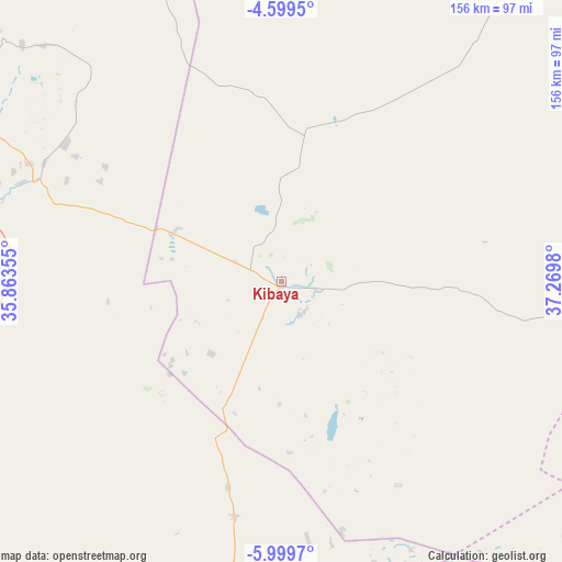
Kibaya GPS coordinates[2]
5° 18' 0" South, 36° 34' 0.012" East
| Map corner | latitude | longitude |
|---|---|---|
| Upper-left | -4.5995°, | 35.86355° |
| Center: | -5.3°, | 36.56667° |
| Lower-right: | -5.9997°, | 37.2698° |
| Map W x H: | 155.7×155.7 km | = 96.7×96.7mi |
| max Lat: | -1.14389° ⇑50.7% North |
| Kibaya: | -5.3° |
| min Lat: | ⇓49.3% South -11.36667° |
| min Long | Kibaya | max Long |
| 29.62667° | 36.56667° | 40.33333° |
| W 60.8%⇐ | ⇒39.2% E |
Elevation
Elevation of Kibaya is 1579 m = 5180 ft, and this is 636.2 m = 2087 ft above average elevation for this country.
| Max E: |
2377 m = 7799 ft | 11.9% |
| Kibaya | 1579 m 5180 ft | |
| Avg. | 942.8 m = 3093 ft | |
Min E: |
0 m = 0 ft | 88.1% |
See also: Tanzania elevation on elevation.city.
Geographical zone
Kibaya is located in South Torrid zone (between Equator and Tropic of Capricorn). Distance of Equator is 589.3 km =366.2 mi to North.| Distance of | km | miles | from Kibaya |
|---|---|---|---|
| Equator | 589.3 | 366.2 | to North |
| Tropic Capricorn | 2016.6 | 1253.1 | to South |
| Antarctic Circle | 6811.9 | 4232.7 | to South |
| South Pole | 9417.8 | 5851.9 | to South |


Nearby cities:
15 places around Kibaya: (largest is in red/bold)
• Babati
150.7 km =93.6 mi,  323°
323°
• Dodoma
133.3 km =82.8 mi,  223°
223°
• Endasak
152.2 km =94.6 mi,  310°
310°
• Galappo
139.7 km =86.8 mi,  325°
325°
• Geiro
100.2 km =62.3 mi,  160°
160°
• Kisasa
129.6 km =80.5 mi, 221°
• Kondoa
97.5 km =60.6 mi,  297°
297°
• Kongwa
101.4 km =63 mi,  189°
189°
• Magole
149.4 km =92.8 mi,  143°
143°
• Mpwapwa
117.1 km =72.8 mi,  184°
184°
• Msanga
102.2 km =63.5 mi, 215°
• Msowero
154 km =95.7 mi,  152°
152°
• Mvomero
147.7 km =91.8 mi, 138°
• Naberera
128.9 km =80.1 mi,  18°
18°
• Nangwa
154.6 km =96.1 mi, 306°
Sources, notices
• [Note1] Compared only with cities in Tanzania existing in our database
• [Src1] Map data: © OpenStreetMap contributors (CC-BY-SA)
• [Src2] Other city data from geonames.org with taken over terms of usage.
• [Src3] Geographical zone / Annual Mean Temperature by Robert A. Rohde @ Wikipedia
