Mtwara geodata
Mtwara is a seat of a first-order administrative division; located in Tanzania in Africa/Dar_es_Salaam (GMT+3) time zone. With population of 96,602 people, there are 16 cities with bigger population in this country. Compared to other cities in Tanzania, 89.5% of cities are located further ↑North; 99.7% of cities are located further ←West and 96.2% of cities have higher elevation than Mtwara. Note1


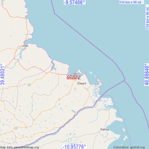
Mtwara GPS coordinates[2]
10° 16' 0.012" South, 40° 10' 59.988" East
| Map corner | latitude | longitude |
|---|---|---|
| Upper-left | -9.57406°, | 39.48021° |
| Center: | -10.26667°, | 40.18333° |
| Lower-right: | -10.95776°, | 40.88646° |
| Map W x H: | 153.9×153.9 km | = 95.6×95.6mi |
| max Lat: | -1.14389° ⇑89.5% North |
| Mtwara: | -10.26667° |
| min Lat: | ⇓10.5% South -11.36667° |
| min Long | Mtwara | max Long |
| 29.62667° | 40.18333° | 40.33333° |
| W 99.7%⇐ | ⇒0.3% E |
Elevation
Elevation of Mtwara is 21 m = 69 ft, and this is 921.8 m = 3024 ft below average elevation for this country.
| Max E: |
2377 m = 7799 ft | 96.2% |
| Avg. | 942.8 m = 3093 ft | |
| Mtwara | 21 m = 69 ft | |
Min E: |
0 m = 0 ft | 3.8% |
See also: Mtwara elevation on elevation.city.
Geographical zone
Mtwara is located in South Torrid zone (between Equator and Tropic of Capricorn). Distance of Equator is 1141.5 km =709.3 mi to North.| Distance of | km | miles | from Mtwara |
|---|---|---|---|
| Equator | 1141.5 | 709.3 | to North |
| Tropic Capricorn | 1464.4 | 909.9 | to South |
| Antarctic Circle | 6259.6 | 3889.5 | to South |
| South Pole | 8865.5 | 5508.8 | to South |


Nearby cities:
15 places around Mtwara: (largest is in red/bold)
• Kitama
70.2 km =43.6 mi,  224°
224°
• Kitangari
102.2 km =63.5 mi,  245°
245°
• Lindi
59.2 km =36.8 mi,  300°
300°
• Luchingu
116.6 km =72.5 mi,  232°
232°
• Madimba
22.1 km =13.7 mi,  132°
132°
• Mahuta
104.3 km =64.8 mi, 230°
• Mingoyo
64.4 km =40 mi,  286°
286°
• Mtama
89.4 km =55.6 mi,  267°
267°
• Namikupa
89.6 km =55.7 mi, 225°
• Nanganga
113.8 km =70.7 mi,  263°
263°
• Nanhyanga
91.2 km =56.7 mi, 229°
• Nanyamba
60.1 km =37.3 mi, 219°
• Newala Kisimani
124.3 km =77.2 mi, 232°
• Nyangao
98.7 km =61.3 mi, 265°
• Tandahimba
80.6 km =50.1 mi, 228°
Sources, notices
• [Note1] Compared only with cities in Tanzania existing in our database
• [Src1] Map data: © OpenStreetMap contributors (CC-BY-SA)
• [Src2] Other city data from geonames.org with taken over terms of usage.
• [Src3] Geographical zone / Annual Mean Temperature by Robert A. Rohde @ Wikipedia
