Lindi geodata
Lindi is a seat of a first-order administrative division; located in Tanzania in Africa/Dar_es_Salaam (GMT+3) time zone. With population of 41,912 people, there are 32 cities with bigger population in this country. Compared to other cities in Tanzania, 88.1% of cities are located further ↑North; 97.2% of cities are located further ←West and 97.9% of cities have higher elevation than Lindi. Note1


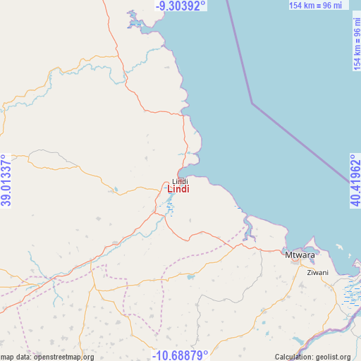
Lindi GPS coordinates[2]
9° 59' 49.524" South, 39° 42' 59.364" East
| Map corner | latitude | longitude |
|---|---|---|
| Upper-left | -9.30392°, | 39.01337° |
| Center: | -9.99709°, | 39.71649° |
| Lower-right: | -10.68879°, | 40.41962° |
| Map W x H: | 154×154 km | = 95.7×95.7mi |
| max Lat: | -1.14389° ⇑88.1% North |
| Lindi: | -9.99709° |
| min Lat: | ⇓11.9% South -11.36667° |
| min Long | Lindi | max Long |
| 29.62667° | 39.71649° | 40.33333° |
| W 97.2%⇐ | ⇒2.8% E |
Elevation
Elevation of Lindi is 12 m = 39 ft, and this is 930.8 m = 3054 ft below average elevation for this country.
| Max E: |
2377 m = 7799 ft | 97.9% |
| Avg. | 942.8 m = 3093 ft | |
| Lindi | 12 m = 39 ft | |
Min E: |
0 m = 0 ft | 2.1% |
See also: Lindi elevation on elevation.city.
Geographical zone
Lindi is located in South Torrid zone (between Equator and Tropic of Capricorn). Distance of Equator is 1111.6 km =690.7 mi to North.| Distance of | km | miles | from Lindi |
|---|---|---|---|
| Equator | 1111.6 | 690.7 | to North |
| Tropic Capricorn | 1494.3 | 928.5 | to South |
| Antarctic Circle | 6289.6 | 3908.2 | to South |
| South Pole | 8895.5 | 5527.4 | to South |


Nearby cities:
15 places around Lindi: (largest is in red/bold)
• Kitama
80 km =49.7 mi,  178°
178°
• Kitangari
83.8 km =52.1 mi,  209°
209°
• Madimba
81 km =50.3 mi,  123°
123°
• Mahuta
101 km =62.8 mi,  196°
196°
• Mbekenyera
80.3 km =49.9 mi,  269°
269°
• Mingoyo
16.1 km =10 mi,  221°
221°
• Mtama
51 km =31.7 mi,  228°
228°
• Mtwara
59.2 km =36.8 mi, 120°
• Namikupa
93.8 km =58.3 mi,  187°
187°
• Nanganga
75.4 km =46.9 mi,  235°
235°
• Nanhyanga
91.1 km =56.6 mi, 191°
• Nanyamba
77.4 km =48.1 mi,  170°
170°
• Nyangao
60.4 km =37.5 mi, 231°
• Ruangwa
86.1 km =53.5 mi,  264°
264°
• Tandahimba
84.2 km =52.3 mi, 186°
Sources, notices
• [Note1] Compared only with cities in Tanzania existing in our database
• [Src1] Map data: © OpenStreetMap contributors (CC-BY-SA)
• [Src2] Other city data from geonames.org with taken over terms of usage.
• [Src3] Geographical zone / Annual Mean Temperature by Robert A. Rohde @ Wikipedia
