Madimba geodata
Madimba (Mtwara) is a populated place; located in Tanzania in Africa/Dar_es_Salaam (GMT+3) time zone. With population of 12,507 people, there are 206 cities with bigger population in this country. Compared to other cities in Tanzania, 91.3% of cities are located further ↑North; 100% of cities are located further ←West and 95.5% of cities have higher elevation than Madimba. Note1


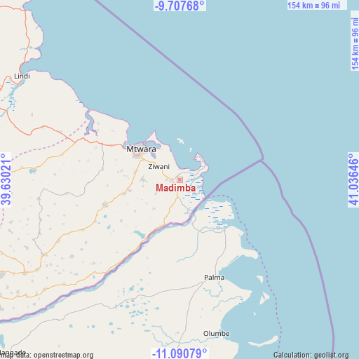
Madimba GPS coordinates[2]
10° 24' 0" South, 40° 19' 59.988" East
| Map corner | latitude | longitude |
|---|---|---|
| Upper-left | -9.70768°, | 39.63021° |
| Center: | -10.4°, | 40.33333° |
| Lower-right: | -11.09079°, | 41.03646° |
| Map W x H: | 153.8×153.8 km | = 95.6×95.6mi |
| max Lat: | -1.14389° ⇑91.3% North |
| Madimba: | -10.4° |
| min Lat: | ⇓8.7% South -11.36667° |
| min Long | Madimba | max Long |
| 29.62667° | 40.33333° | 40.33333° |
| W 100%⇐ | ⇒0% E |
Elevation
Elevation of Madimba is 22 m = 72 ft, and this is 920.8 m = 3021 ft below average elevation for this country.
| Max E: |
2377 m = 7799 ft | 95.5% |
| Avg. | 942.8 m = 3093 ft | |
| Madimba | 22 m = 72 ft | |
Min E: |
0 m = 0 ft | 4.5% |
See also: Tanzania elevation on elevation.city.
Geographical zone
Madimba is located in South Torrid zone (between Equator and Tropic of Capricorn). Distance of Equator is 1156.4 km =718.6 mi to North.| Distance of | km | miles | from Madimba |
|---|---|---|---|
| Equator | 1156.4 | 718.6 | to North |
| Tropic Capricorn | 1449.5 | 900.7 | to South |
| Antarctic Circle | 6244.8 | 3880.3 | to South |
| South Pole | 8850.7 | 5499.6 | to South |


Nearby cities:
15 places around Madimba: (largest is in red/bold)
• Kitama
74.4 km =46.2 mi,  241°
241°
• Kitangari
112.8 km =70.1 mi,  255°
255°
• Lindi
81 km =50.3 mi,  303°
303°
• Luchingu
122.6 km =76.2 mi, 243°
• Mahuta
109.6 km =68.1 mi, 241°
• Mingoyo
84.8 km =52.7 mi,  292°
292°
• Mtama
106.3 km =66.1 mi,  276°
276°
• Mtwara
22.1 km =13.7 mi,  312°
312°
• Namikupa
93.5 km =58.1 mi, 238°
• Nanganga
129.4 km =80.4 mi,  270°
270°
• Nanhyanga
96.5 km =60 mi, 242°
• Nanyamba
63.1 km =39.2 mi, 240°
• Newala Kisimani
130 km =80.8 mi, 241°
• Nyangao
115.1 km =71.5 mi, 273°
• Tandahimba
85.8 km =53.3 mi, 243°
Sources, notices
• [Note1] Compared only with cities in Tanzania existing in our database
• [Src1] Map data: © OpenStreetMap contributors (CC-BY-SA)
• [Src2] Other city data from geonames.org with taken over terms of usage.
• [Src3] Geographical zone / Annual Mean Temperature by Robert A. Rohde @ Wikipedia
