Hvardiiske geodata
Hvardiiske (Republic of Crimea) is a seat of a third-order administrative division; located in Ukraine in Europe/Simferopol (GMT+3) time zone. With population of 772 people, there are 1503 cities with bigger population in this country. Compared to other cities in Ukraine, 75.4% of cities are located further ↑North; 61.9% of cities are located further ←West and 75.7% of cities have higher elevation than Hvardiiske. Note1
Administrative division(s):
- Level 1: Republic of Crimea
- Level 2: Pervomayskiy rayon
- Level 3: Gvardeyskoye sel'skoye poselenye


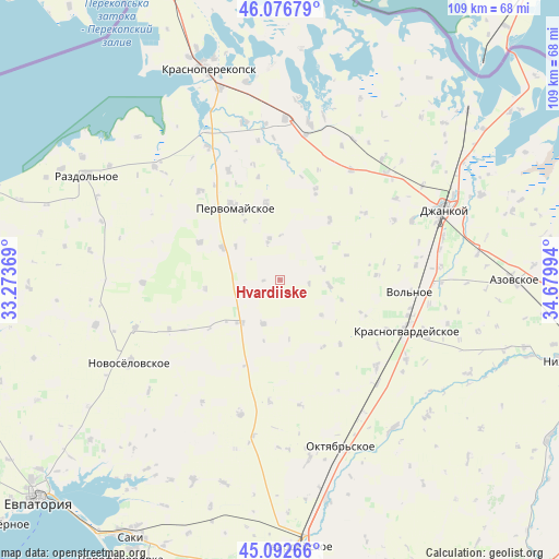
Hvardiiske GPS coordinates[2]
45° 35' 12.768" North, 33° 58' 36.516" East
| Map corner | latitude | longitude |
|---|---|---|
| Upper-left | 46.07679°, | 33.27369° |
| Center: | 45.58688°, | 33.97681° |
| Lower-right: | 45.09266°, | 34.67994° |
| Map W x H: | 109.4×109.4 km | = 68×68mi |
| max Lat: | 52.18903° ⇑75.4% North |
| Hvardiiske: | 45.58688° |
| min Lat: | ⇓24.6% South 44.39214° |
| min Long | Hvardiiske | max Long |
| 22.20555° | 33.97681° | 40.13222° |
| W 61.9%⇐ | ⇒38.1% E |
Elevation
Elevation of Hvardiiske is 58 m = 190 ft, and this is 97.8 m = 321 ft below average elevation for this country.
| Max E: |
886 m = 2907 ft | 75.7% |
| Avg. | 155.8 m = 511 ft | |
| Hvardiiske | 58 m = 190 ft | |
Min E: |
-3 m = -10 ft | 24.3% |
See also: Ukraine elevation on elevation.city.
Geographical zone
Hvardiiske is located in North temperate zone (between Tropic of Cancer and the Arctic Circle). Distance of this North polar circle is 2332.4 km =1449.3 mi to North.| Distance of | km | miles | from Hvardiiske |
|---|---|---|---|
| North Pole | 4938.3 | 3068.5 | to North |
| Arctic Circle | 2332.4 | 1449.3 | to North |
| Tropic Cancer | 2462.9 | 1530.4 | to South |
| Equator | 5068.8 | 3149.6 | to South |


Nearby cities:
15 places around Hvardiiske: (largest is in red/bold)
• Abrikosovo
15.2 km =9.4 mi,  39°
39°
• Aleksandrovka
9.6 km =6 mi,  96°
96°
• Chernovo
9.3 km =5.8 mi,  200°
200°
• Grishino
12.9 km =8 mi,  298°
298°
• Karpovka
10.6 km =6.6 mi,  130°
130°
• Klepinino
17.3 km =10.7 mi,  112°
112°
• Krasnaya Polyana
17.3 km =10.7 mi,  136°
136°
• Kremnevka
15.7 km =9.8 mi,  147°
147°
• Krest’yanovka
15.4 km =9.6 mi,  349°
349°
• Oktyabr’skoye
7.9 km =4.9 mi,  344°
344°
• Roskoshnoye
13 km =8.1 mi,  56°
56°
• Sary-Bash
14.8 km =9.2 mi,  263°
263°
• Stepnoye
17.3 km =10.7 mi,  294°
294°
• Voykovo
11.5 km =7.1 mi,  223°
223°
• Zernovoye
13.8 km =8.6 mi,  69°
69°
Sources, notices
• [Note1] Compared only with cities in Ukraine existing in our database
• [Src1] Map data: © OpenStreetMap contributors (CC-BY-SA)
• [Src2] Other city data from geonames.org with taken over terms of usage.
• [Src3] Geographical zone / Annual Mean Temperature by Robert A. Rohde @ Wikipedia
