Mykolayiv geodata
Mykolayiv (Mykolaiv) is a seat of a first-order administrative division; located in Ukraine in Europe/Kiev (GMT+3) time zone. With population of 510,840 people, there are 8 cities with bigger population in this country. Compared to other cities in Ukraine, 64% of cities are located further ↑North; 57.3% of cities are located further →East and 90.9% of cities have higher elevation than Mykolayiv. Note1


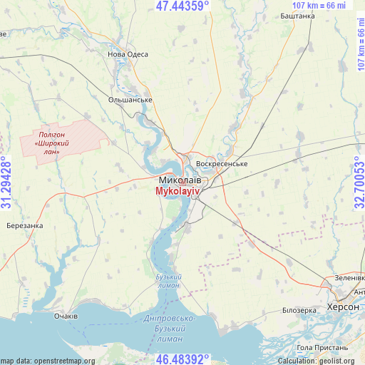
Mykolayiv GPS coordinates[2]
46° 57' 57.276" North, 31° 59' 50.64" East
| Map corner | latitude | longitude |
|---|---|---|
| Upper-left | 47.44359°, | 31.29428° |
| Center: | 46.96591°, | 31.9974° |
| Lower-right: | 46.48392°, | 32.70053° |
| Map W x H: | 106.7×106.7 km | = 66.3×66.3mi |
| max Lat: | 52.18903° ⇑64% North |
| Mykolayiv: | 46.96591° |
| min Lat: | ⇓36% South 44.39214° |
| min Long | Mykolayiv | max Long |
| 22.20555° | 31.9974° | 40.13222° |
| W 42.7%⇐ | ⇒57.3% E |
Elevation
Elevation of Mykolayiv is 18 m = 59 ft, and this is 137.8 m = 452 ft below average elevation for this country.
| Max E: |
886 m = 2907 ft | 90.9% |
| Avg. | 155.8 m = 511 ft | |
| Mykolayiv | 18 m = 59 ft | |
Min E: |
-3 m = -10 ft | 9.1% |
See also: Mykolayiv elevation on elevation.city.
Geographical zone
Mykolayiv is located in North temperate zone (between Tropic of Cancer and the Arctic Circle). Distance of this North polar circle is 2179.1 km =1354 mi to North.| Distance of | km | miles | from Mykolayiv |
|---|---|---|---|
| North Pole | 4784.9 | 2973.2 | to North |
| Arctic Circle | 2179.1 | 1354 | to North |
| Tropic Cancer | 2616.2 | 1625.6 | to South |
| Equator | 5222.1 | 3244.9 | to South |


Nearby cities:
15 places around Mykolayiv: (largest is in red/bold)
• Bashtanka
59.3 km =36.8 mi,  34°
34°
• Berezanka
48 km =29.8 mi,  254°
254°
• Bilozerka
50.9 km =31.6 mi,  138°
138°
• Chornobayivka
52 km =32.3 mi,  125°
125°
• Kherson
58.5 km =36.4 mi, 126°
• Komyshany
53.3 km =33.1 mi, 133°
• Nova Odesa
41.3 km =25.7 mi,  337°
337°
• Ochakiv
52 km =32.3 mi,  220°
220°
• Ol'shanskoye
28.7 km =17.8 mi,  327°
327°
• Oleksandrivka
59.7 km =37.1 mi,  103°
103°
• Parutyne
30 km =18.6 mi,  194°
194°
• Shevchenkove
19.4 km =12.1 mi, 126°
• Snihurivka
62.4 km =38.8 mi,  78°
78°
• Stanislav
45.6 km =28.3 mi,  165°
165°
• Геройское
51.3 km =31.9 mi, 189°
Sources, notices
• [Note1] Compared only with cities in Ukraine existing in our database
• [Src1] Map data: © OpenStreetMap contributors (CC-BY-SA)
• [Src2] Other city data from geonames.org with taken over terms of usage.
• [Src3] Geographical zone / Annual Mean Temperature by Robert A. Rohde @ Wikipedia
