Vishnyovka geodata
Vishnyovka (Republic of Crimea) is a seat of a third-order administrative division; located in Ukraine in Europe/Simferopol (GMT+3) time zone. With population of 995 people, there are 1386 cities with bigger population in this country. Compared to other cities in Ukraine, 70.2% of cities are located further ↑North; 61.4% of cities are located further ←West and 99.3% of cities have higher elevation than Vishnyovka. Note1
Administrative division(s):
- Level 1: Republic of Crimea
- Level 2: Krasnoperekopsk Raion
- Level 3: Vishnyovskoye sel'skoye poselenye


Vishnyovka GPS coordinates[2]
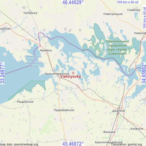
45° 57' 34.776" North, 33° 57' 10.404" East
| Map corner | latitude | longitude |
|---|---|---|
| Upper-left | 46.44629°, | 33.24977° |
| Center: | 45.95966°, | 33.95289° |
| Lower-right: | 45.46872°, | 34.65602° |
| Map W x H: | 108.7×108.7 km | = 67.5×67.5mi |
| max Lat: | 52.18903° ⇑70.2% North |
| Vishnyovka: | 45.95966° |
| min Lat: | ⇓29.8% South 44.39214° |
| min Long | Vishnyovka | max Long |
| 22.20555° | 33.95289° | 40.13222° |
| W 61.4%⇐ | ⇒38.6% E |
Elevation
Elevation of Vishnyovka is 4 m = 13 ft, and this is 151.8 m = 498 ft below average elevation for this country.
| Max E: |
886 m = 2907 ft | 99.3% |
| Avg. | 155.8 m = 511 ft | |
| Vishnyovka | 4 m = 13 ft | |
Min E: |
-3 m = -10 ft | 0.7% |
See also: Ukraine elevation on elevation.city.
Geographical zone
Vishnyovka is located in North temperate zone (between Tropic of Cancer and the Arctic Circle). Distance of this North polar circle is 2290.9 km =1423.5 mi to North.| Distance of | km | miles | from Vishnyovka |
|---|---|---|---|
| North Pole | 4896.8 | 3042.7 | to North |
| Arctic Circle | 2290.9 | 1423.5 | to North |
| Tropic Cancer | 2504.3 | 1556.1 | to South |
| Equator | 5110.2 | 3175.3 | to South |


Nearby cities:
15 places around Vishnyovka: (largest is in red/bold)
• Bratskoye
14.4 km =8.9 mi,  189°
189°
• Dolinka
10.9 km =6.8 mi,  184°
184°
• Ishun’
10.8 km =6.7 mi,  248°
248°
• Istochnoye
8.2 km =5.1 mi,  136°
136°
• Krasnoarmeyskoye
6.9 km =4.3 mi,  59°
59°
• Krasnoperekops’k
12.1 km =7.5 mi,  268°
268°
• Magazinka
13.1 km =8.1 mi,  145°
145°
• Novoivanovka
15 km =9.3 mi, 152°
• Novopavlovka
11.5 km =7.1 mi,  205°
205°
• Orlovskoye
16.6 km =10.3 mi,  174°
174°
• Pochetnoye
15 km =9.3 mi,  285°
285°
• Sovkhoznoye
14 km =8.7 mi, 270°
• Tavricheskoye
15.9 km =9.9 mi,  276°
276°
• Voinka
10.4 km =6.5 mi,  163°
163°
• Zelyonaya Niva
5.5 km =3.4 mi,  239°
239°
Sources, notices
• [Note1] Compared only with cities in Ukraine existing in our database
• [Src1] Map data: © OpenStreetMap contributors (CC-BY-SA)
• [Src2] Other city data from geonames.org with taken over terms of usage.
• [Src3] Geographical zone / Annual Mean Temperature by Robert A. Rohde @ Wikipedia
