Pochetnoye geodata
Pochetnoye (Republic of Crimea) is a seat of a third-order administrative division; located in Ukraine in Europe/Simferopol (GMT+3) time zone. With population of 1,247 people, there are 1284 cities with bigger population in this country. Compared to other cities in Ukraine, 69.8% of cities are located further ↑North; 56.8% of cities are located further ←West and 95.8% of cities have higher elevation than Pochetnoye. Note1
Administrative division(s):
- Level 1: Republic of Crimea
- Level 2: Krasnoperekopsk Raion
- Level 3: Pochetnenskoye sel'skoye poselenye


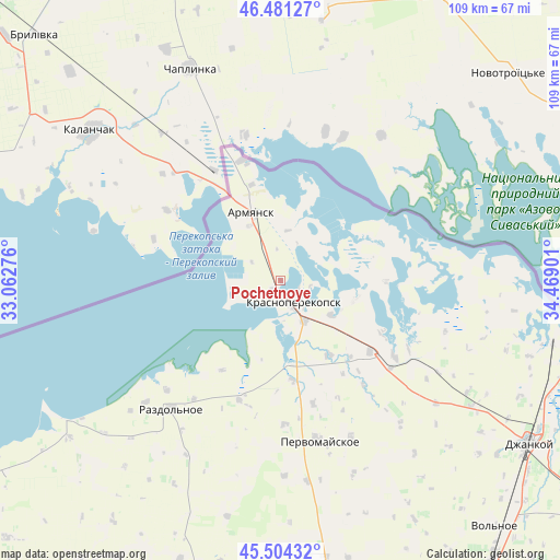
Pochetnoye GPS coordinates[2]
45° 59' 41.82" North, 33° 45' 57.168" East
| Map corner | latitude | longitude |
|---|---|---|
| Upper-left | 46.48127°, | 33.06276° |
| Center: | 45.99495°, | 33.76588° |
| Lower-right: | 45.50432°, | 34.46901° |
| Map W x H: | 108.6×108.6 km | = 67.5×67.5mi |
| max Lat: | 52.18903° ⇑69.8% North |
| Pochetnoye: | 45.99495° |
| min Lat: | ⇓30.2% South 44.39214° |
| min Long | Pochetnoye | max Long |
| 22.20555° | 33.76588° | 40.13222° |
| W 56.8%⇐ | ⇒43.2% E |
Elevation
Elevation of Pochetnoye is 10 m = 33 ft, and this is 145.8 m = 478 ft below average elevation for this country.
| Max E: |
886 m = 2907 ft | 95.8% |
| Avg. | 155.8 m = 511 ft | |
| Pochetnoye | 10 m = 33 ft | |
Min E: |
-3 m = -10 ft | 4.2% |
See also: Ukraine elevation on elevation.city.
Geographical zone
Pochetnoye is located in North temperate zone (between Tropic of Cancer and the Arctic Circle). Distance of this North polar circle is 2287 km =1421.1 mi to North.| Distance of | km | miles | from Pochetnoye |
|---|---|---|---|
| North Pole | 4892.9 | 3040.3 | to North |
| Arctic Circle | 2287 | 1421.1 | to North |
| Tropic Cancer | 2508.2 | 1558.5 | to South |
| Equator | 5114.2 | 3177.8 | to South |


Nearby cities:
15 places around Pochetnoye: (largest is in red/bold)
• Armyansk
13.9 km =8.6 mi,  335°
335°
• Dolinka
20.1 km =12.5 mi,  137°
137°
• Filatovka
9.8 km =6.1 mi,  8°
8°
• Ilyinka
19.8 km =12.3 mi,  173°
173°
• Ishun’
9.1 km =5.7 mi,  150°
150°
• Krasnoarmeyskoye
20.4 km =12.7 mi,  91°
91°
• Krasnoperekops’k
4.8 km =3 mi, 150°
• Novopavlovka
17.2 km =10.7 mi, 146°
• Perekop
19.4 km =12.1 mi, 343°
• Risovoye
6.7 km =4.2 mi,  302°
302°
• Sovkhoznoye
3.9 km =2.4 mi, 173°
• Suvorovo
12 km =7.5 mi,  330°
330°
• Tavricheskoye
2.4 km =1.5 mi,  212°
212°
• Vishnyovka
15 km =9.3 mi,  105°
105°
• Zelyonaya Niva
11.8 km =7.3 mi,  124°
124°
Sources, notices
• [Note1] Compared only with cities in Ukraine existing in our database
• [Src1] Map data: © OpenStreetMap contributors (CC-BY-SA)
• [Src2] Other city data from geonames.org with taken over terms of usage.
• [Src3] Geographical zone / Annual Mean Temperature by Robert A. Rohde @ Wikipedia
