Svirzh geodata
Svirzh (Lviv) is a populated place; located in Ukraine in Europe/Kiev (GMT+3) time zone. With population of 795 people, there are 1486 cities with bigger population in this country. Compared to other cities in Ukraine, 76.8% of cities are located further ↓South; 89.6% of cities are located further →East and 93.8% of cities have lower elevation than Svirzh. Note1


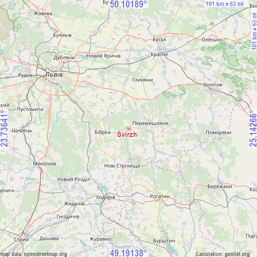
Svirzh GPS coordinates[2]
49° 38' 55.536" North, 24° 26' 22.308" East
| Map corner | latitude | longitude |
|---|---|---|
| Upper-left | 50.10189°, | 23.73641° |
| Center: | 49.64876°, | 24.43953° |
| Lower-right: | 49.19138°, | 25.14266° |
| Map W x H: | 101.2×101.2 km | = 62.9×62.9mi |
| max Lat: | 52.18903° ⇑23.2% North |
| Svirzh: | 49.64876° |
| min Lat: | ⇓76.8% South 44.39214° |
| min Long | Svirzh | max Long |
| 22.20555° | 24.43953° | 40.13222° |
| W 10.4%⇐ | ⇒89.6% E |
Elevation
Elevation of Svirzh is 343 m = 1125 ft, and this is 187.2 m = 614 ft above average elevation for this country.
| Max E: |
886 m = 2907 ft | 6.2% |
| Svirzh | 343 m 1125 ft | |
| Avg. | 155.8 m = 511 ft | |
Min E: |
-3 m = -10 ft | 93.8% |
See also: Ukraine elevation on elevation.city.
Geographical zone
Svirzh is located in North temperate zone (between Tropic of Cancer and the Arctic Circle). Distance of this North polar circle is 1880.7 km =1168.6 mi to North.| Distance of | km | miles | from Svirzh |
|---|---|---|---|
| North Pole | 4486.6 | 2787.8 | to North |
| Arctic Circle | 1880.7 | 1168.6 | to North |
| Tropic Cancer | 2914.5 | 1811 | to South |
| Equator | 5520.4 | 3430.2 | to South |


Nearby cities:
15 places around Svirzh: (largest is in red/bold)
• Bibrka
10.9 km =6.8 mi,  265°
265°
• Dunayiv
28 km =17.4 mi,  97°
97°
• Dzvinogrud
16.6 km =10.3 mi,  304°
304°
• Khodoriv
28.3 km =17.6 mi,  200°
200°
• Krasne
32.1 km =19.9 mi,  22°
22°
• Novi Strilyscha
15 km =9.3 mi,  189°
189°
• Novyi Yarychiv
30 km =18.6 mi,  341°
341°
• Peremyshlyany
8.8 km =5.5 mi,  77°
77°
• Rohatyn
29.3 km =18.2 mi,  155°
155°
• Rozdil
34.3 km =21.3 mi,  232°
232°
• Shpyl’chyna
11.5 km =7.1 mi,  278°
278°
• Solonka
33.1 km =20.6 mi,  291°
291°
• Staroye Selo
19.2 km =11.9 mi, 290°
• Verkhnyaya Belka
21 km =13 mi,  332°
332°
• Vyshnivchyk
22.8 km =14.2 mi, 75°
Sources, notices
• [Note1] Compared only with cities in Ukraine existing in our database
• [Src1] Map data: © OpenStreetMap contributors (CC-BY-SA)
• [Src2] Other city data from geonames.org with taken over terms of usage.
• [Src3] Geographical zone / Annual Mean Temperature by Robert A. Rohde @ Wikipedia
