Bus’k geodata
Bus’k (Lviv) is a seat of a second-order administrative division; located in Ukraine in Europe/Kiev (GMT+3) time zone. In our database, there are 1661 cities with bigger population. Compared to other cities in Ukraine, 83% of cities are located further ↓South; 88.7% of cities are located further →East and 73.3% of cities have lower elevation than Bus’k. Note1


Bus’k GPS coordinates[2]
49° 57' 55.728" North, 24° 36' 44.172" East
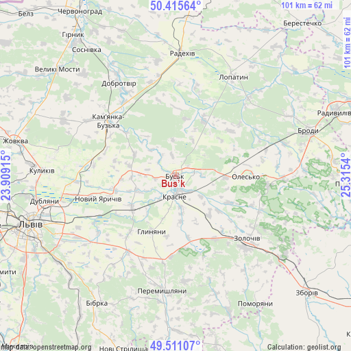
| Map corner | latitude | longitude |
|---|---|---|
| Upper-left | 50.41564°, | 23.90915° |
| Center: | 49.96548°, | 24.61227° |
| Lower-right: | 49.51107°, | 25.3154° |
| Map W x H: | 100.6×100.6 km | = 62.5×62.5mi |
| max Lat: | 52.18903° ⇑17% North |
| Bus’k: | 49.96548° |
| min Lat: | ⇓83% South 44.39214° |
| min Long | Bus’k | max Long |
| 22.20555° | 24.61227° | 40.13222° |
| W 11.3%⇐ | ⇒88.7% E |
Elevation
Elevation of Bus’k is 218 m = 715 ft, and this is 62.2 m = 204 ft above average elevation for this country.
| Max E: |
886 m = 2907 ft | 26.7% |
| Bus’k | 218 m 715 ft | |
| Avg. | 155.8 m = 511 ft | |
Min E: |
-3 m = -10 ft | 73.3% |
See also: Ukraine elevation on elevation.city.
Geographical zone
Bus’k is located in North temperate zone (between Tropic of Cancer and the Arctic Circle). Distance of this North polar circle is 1845.5 km =1146.7 mi to North.| Distance of | km | miles | from Bus’k |
|---|---|---|---|
| North Pole | 4451.4 | 2766 | to North |
| Arctic Circle | 1845.5 | 1146.7 | to North |
| Tropic Cancer | 2949.7 | 1832.9 | to South |
| Equator | 5555.6 | 3452.1 | to South |


Nearby cities:
15 places around Bus’k: (largest is in red/bold)
• Dzvinogrud
36.6 km =22.7 mi,  225°
225°
• Kamianka-Buzka
24.7 km =15.3 mi,  309°
309°
• Krasne
5.7 km =3.5 mi,  179°
179°
• Kulykiv
38.2 km =23.7 mi,  272°
272°
• Lopatyn
33 km =20.5 mi,  30°
30°
• Novyi Yarychiv
23 km =14.3 mi,  252°
252°
• Olesko
20.1 km =12.5 mi,  90°
90°
• Peremyshlyany
33.6 km =20.9 mi,  186°
186°
• Pidhirtsi
26.4 km =16.4 mi, 94°
• Radekhiv
35.3 km =21.9 mi,  3°
3°
• Staryy Dobrotvir
34 km =21.1 mi,  330°
330°
• Svirzh
37.3 km =23.2 mi,  199°
199°
• Verkhnyaya Belka
27.7 km =17.2 mi, 233°
• Vyshnivchyk
31 km =19.3 mi,  161°
161°
• Zolochiv
26.9 km =16.7 mi,  131°
131°
Sources, notices
• [Note1] Compared only with cities in Ukraine existing in our database
• [Src1] Map data: © OpenStreetMap contributors (CC-BY-SA)
• [Src2] Other city data from geonames.org with taken over terms of usage.
• [Src3] Geographical zone / Annual Mean Temperature by Robert A. Rohde @ Wikipedia
