Vary geodata
Vary (Transcarpathia) is a populated place; located in Ukraine in Europe/Uzhgorod (GMT+3) time zone. With population of 2,998 people, there are 944 cities with bigger population in this country. Compared to other cities in Ukraine, 54.2% of cities are located further ↑North; 99% of cities are located further →East and 57.7% of cities have higher elevation than Vary. Note1


Vary GPS coordinates[2]
48° 7' 19.452" North, 22° 42' 46.116" East
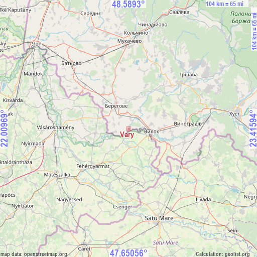
| Map corner | latitude | longitude |
|---|---|---|
| Upper-left | 48.5893°, | 22.00969° |
| Center: | 48.12207°, | 22.71281° |
| Lower-right: | 47.65056°, | 23.41594° |
| Map W x H: | 104.4×104.4 km | = 64.9×64.9mi |
| max Lat: | 52.18903° ⇑54.2% North |
| Vary: | 48.12207° |
| min Lat: | ⇓45.8% South 44.39214° |
| min Long | Vary | max Long |
| 22.20555° | 22.71281° | 40.13222° |
| W 1%⇐ | ⇒99% E |
Elevation
Elevation of Vary is 113 m = 371 ft, and this is 42.8 m = 140 ft below average elevation for this country.
| Max E: |
886 m = 2907 ft | 57.7% |
| Avg. | 155.8 m = 511 ft | |
| Vary | 113 m = 371 ft | |
Min E: |
-3 m = -10 ft | 42.3% |
See also: Ukraine elevation on elevation.city.
Geographical zone
Vary is located in North temperate zone (between Tropic of Cancer and the Arctic Circle). Distance of this North polar circle is 2050.5 km =1274.1 mi to North.| Distance of | km | miles | from Vary |
|---|---|---|---|
| North Pole | 4656.4 | 2893.4 | to North |
| Arctic Circle | 2050.5 | 1274.1 | to North |
| Tropic Cancer | 2744.8 | 1705.5 | to South |
| Equator | 5350.7 | 3324.8 | to South |


Nearby cities:
15 places around Vary: (largest is in red/bold)
• Batiovo
35.3 km =21.9 mi,  318°
318°
• Berehove
10.6 km =6.6 mi,  331°
331°
• Bobovo
14.7 km =9.1 mi,  112°
112°
• Chetfalva
6.1 km =3.8 mi,  85°
85°
• Irshava
32.4 km =20.1 mi,  48°
48°
• Korolevo
31.6 km =19.6 mi,  83°
83°
• Koson’
24.1 km =15 mi,  307°
307°
• Mukacheve
35.3 km =21.9 mi,  0°
0°
• Muzhiyevo
6.5 km =4 mi,  351°
351°
• Oleshnyk
19 km =11.8 mi, 75°
• Pidvynohradiv
19.3 km =12 mi, 84°
• Strabychovo
32.6 km =20.3 mi,  337°
337°
• Velyki Berehy
12.5 km =7.8 mi,  11°
11°
• Vylok
9.5 km =5.9 mi,  98°
98°
• Vynohradiv
23.4 km =14.5 mi, 84°
Sources, notices
• [Note1] Compared only with cities in Ukraine existing in our database
• [Src1] Map data: © OpenStreetMap contributors (CC-BY-SA)
• [Src2] Other city data from geonames.org with taken over terms of usage.
• [Src3] Geographical zone / Annual Mean Temperature by Robert A. Rohde @ Wikipedia
