Oleshnyk geodata
Oleshnyk (Transcarpathia) is a populated place; located in Ukraine in Europe/Uzhgorod (GMT+3) time zone. With population of 4,696 people, there are 679 cities with bigger population in this country. Compared to other cities in Ukraine, 53.1% of cities are located further ↑North; 98.4% of cities are located further →East and 53.1% of cities have higher elevation than Oleshnyk. Note1


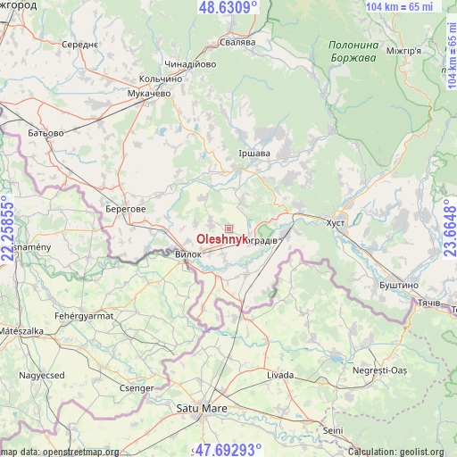
Oleshnyk GPS coordinates[2]
48° 9' 50.616" North, 22° 57' 42.012" East
| Map corner | latitude | longitude |
|---|---|---|
| Upper-left | 48.6309°, | 22.25855° |
| Center: | 48.16406°, | 22.96167° |
| Lower-right: | 47.69293°, | 23.6648° |
| Map W x H: | 104.3×104.3 km | = 64.8×64.8mi |
| max Lat: | 52.18903° ⇑53.1% North |
| Oleshnyk: | 48.16406° |
| min Lat: | ⇓46.9% South 44.39214° |
| min Long | Oleshnyk | max Long |
| 22.20555° | 22.96167° | 40.13222° |
| W 1.6%⇐ | ⇒98.4% E |
Elevation
Elevation of Oleshnyk is 125 m = 410 ft, and this is 30.8 m = 101 ft below average elevation for this country.
| Max E: |
886 m = 2907 ft | 53.1% |
| Avg. | 155.8 m = 511 ft | |
| Oleshnyk | 125 m = 410 ft | |
Min E: |
-3 m = -10 ft | 46.9% |
See also: Ukraine elevation on elevation.city.
Geographical zone
Oleshnyk is located in North temperate zone (between Tropic of Cancer and the Arctic Circle). Distance of this North polar circle is 2045.8 km =1271.2 mi to North.| Distance of | km | miles | from Oleshnyk |
|---|---|---|---|
| North Pole | 4651.7 | 2890.4 | to North |
| Arctic Circle | 2045.8 | 1271.2 | to North |
| Tropic Cancer | 2749.4 | 1708.4 | to South |
| Equator | 5355.3 | 3327.6 | to South |


Nearby cities:
15 places around Oleshnyk: (largest is in red/bold)
• Berehove
24 km =14.9 mi,  281°
281°
• Bilky
21 km =13 mi,  36°
36°
• Bobovo
11.4 km =7.1 mi,  205°
205°
• Chetfalva
13.1 km =8.1 mi,  251°
251°
• Irshava
17.9 km =11.1 mi,  18°
18°
• Khust
25.1 km =15.6 mi,  86°
86°
• Korolevo
13 km =8.1 mi,  95°
95°
• Kryva
20.4 km =12.7 mi, 87°
• Muzhiyevo
19.5 km =12.1 mi, 275°
• Pidvynohradiv
2.8 km =1.7 mi,  164°
164°
• Rokosovo
16.7 km =10.4 mi,  72°
72°
• Vary
19 km =11.8 mi,  255°
255°
• Velyki Berehy
17.7 km =11 mi,  295°
295°
• Vylok
11 km =6.8 mi,  236°
236°
• Vynohradiv
5.4 km =3.4 mi,  117°
117°
Sources, notices
• [Note1] Compared only with cities in Ukraine existing in our database
• [Src1] Map data: © OpenStreetMap contributors (CC-BY-SA)
• [Src2] Other city data from geonames.org with taken over terms of usage.
• [Src3] Geographical zone / Annual Mean Temperature by Robert A. Rohde @ Wikipedia
