Korolevo geodata
Korolevo (Transcarpathia) is a populated place; located in Ukraine in Europe/Uzhgorod (GMT+3) time zone. With population of 7,844 people, there are 454 cities with bigger population in this country. Compared to other cities in Ukraine, 53.4% of cities are located further ↑North; 97.8% of cities are located further →East and 52.6% of cities have lower elevation than Korolevo. Note1


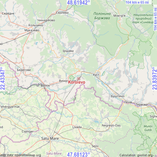
Korolevo GPS coordinates[2]
48° 9' 8.892" North, 23° 8' 11.724" East
| Map corner | latitude | longitude |
|---|---|---|
| Upper-left | 48.61942°, | 22.43347° |
| Center: | 48.15247°, | 23.13659° |
| Lower-right: | 47.68123°, | 23.83972° |
| Map W x H: | 104.3×104.3 km | = 64.8×64.8mi |
| max Lat: | 52.18903° ⇑53.4% North |
| Korolevo: | 48.15247° |
| min Lat: | ⇓46.6% South 44.39214° |
| min Long | Korolevo | max Long |
| 22.20555° | 23.13659° | 40.13222° |
| W 2.2%⇐ | ⇒97.8% E |
Elevation
Elevation of Korolevo is 144 m = 472 ft, and this is 11.8 m = 39 ft below average elevation for this country.
| Max E: |
886 m = 2907 ft | 47.4% |
| Avg. | 155.8 m = 511 ft | |
| Korolevo | 144 m = 472 ft | |
Min E: |
-3 m = -10 ft | 52.6% |
See also: Ukraine elevation on elevation.city.
Geographical zone
Korolevo is located in North temperate zone (between Tropic of Cancer and the Arctic Circle). Distance of this North polar circle is 2047.1 km =1272 mi to North.| Distance of | km | miles | from Korolevo |
|---|---|---|---|
| North Pole | 4653 | 2891.2 | to North |
| Arctic Circle | 2047.1 | 1272 | to North |
| Tropic Cancer | 2748.1 | 1707.6 | to South |
| Equator | 5354.1 | 3326.9 | to South |


Nearby cities:
15 places around Korolevo: (largest is in red/bold)
• Bilky
18.1 km =11.2 mi,  359°
359°
• Bobovo
20 km =12.4 mi,  243°
243°
• Chetfalva
25.6 km =15.9 mi,  263°
263°
• Irshava
19.7 km =12.2 mi,  338°
338°
• Iza
15.9 km =9.9 mi,  63°
63°
• Khust
12.4 km =7.7 mi,  76°
76°
• Kryva
7.7 km =4.8 mi,  73°
73°
• Lypcha
21.9 km =13.6 mi, 56°
• Nyzhnye Selyshche
23.6 km =14.7 mi, 77°
• Oleshnyk
13 km =8.1 mi,  275°
275°
• Pidvynohradiv
12.3 km =7.6 mi, 263°
• Rokosovo
7.1 km =4.4 mi,  24°
24°
• Vylok
22.6 km =14 mi, 257°
• Vynohradiv
8.2 km =5.1 mi, 261°
• Vyshkovo
24.1 km =15 mi,  118°
118°
Sources, notices
• [Note1] Compared only with cities in Ukraine existing in our database
• [Src1] Map data: © OpenStreetMap contributors (CC-BY-SA)
• [Src2] Other city data from geonames.org with taken over terms of usage.
• [Src3] Geographical zone / Annual Mean Temperature by Robert A. Rohde @ Wikipedia
