Chetfalva geodata
Chetfalva (Transcarpathia) is a populated place; located in Ukraine in Europe/Uzhgorod (GMT+3) time zone. With population of 755 people, there are 1506 cities with bigger population in this country. Compared to other cities in Ukraine, 54.1% of cities are located further ↑North; 98.7% of cities are located further →East and 56.5% of cities have higher elevation than Chetfalva. Note1


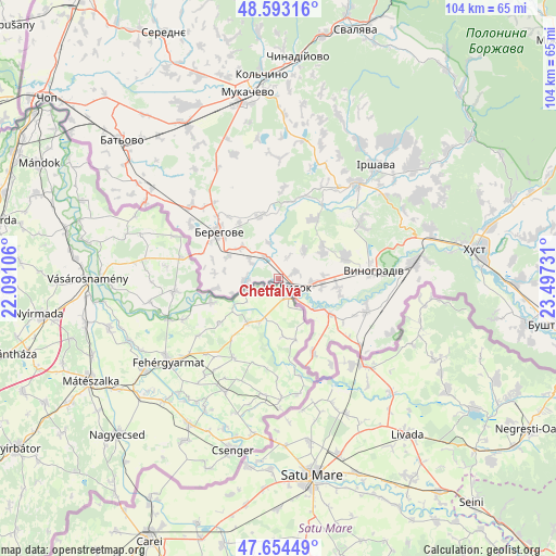
Chetfalva GPS coordinates[2]
48° 7' 33.492" North, 22° 47' 39.048" East
| Map corner | latitude | longitude |
|---|---|---|
| Upper-left | 48.59316°, | 22.09106° |
| Center: | 48.12597°, | 22.79418° |
| Lower-right: | 47.65449°, | 23.49731° |
| Map W x H: | 104.4×104.4 km | = 64.9×64.9mi |
| max Lat: | 52.18903° ⇑54.1% North |
| Chetfalva: | 48.12597° |
| min Lat: | ⇓45.9% South 44.39214° |
| min Long | Chetfalva | max Long |
| 22.20555° | 22.79418° | 40.13222° |
| W 1.3%⇐ | ⇒98.7% E |
Elevation
Elevation of Chetfalva is 116 m = 381 ft, and this is 39.8 m = 131 ft below average elevation for this country.
| Max E: |
886 m = 2907 ft | 56.5% |
| Avg. | 155.8 m = 511 ft | |
| Chetfalva | 116 m = 381 ft | |
Min E: |
-3 m = -10 ft | 43.5% |
See also: Ukraine elevation on elevation.city.
Geographical zone
Chetfalva is located in North temperate zone (between Tropic of Cancer and the Arctic Circle). Distance of this North polar circle is 2050.1 km =1273.9 mi to North.| Distance of | km | miles | from Chetfalva |
|---|---|---|---|
| North Pole | 4656 | 2893.1 | to North |
| Arctic Circle | 2050.1 | 1273.9 | to North |
| Tropic Cancer | 2745.2 | 1705.8 | to South |
| Equator | 5351.1 | 3325 | to South |


Nearby cities:
15 places around Chetfalva: (largest is in red/bold)
• Berehove
14.2 km =8.8 mi,  308°
308°
• Bilky
32.7 km =20.3 mi,  50°
50°
• Bobovo
9.7 km =6 mi,  128°
128°
• Irshava
27.9 km =17.3 mi,  40°
40°
• Korolevo
25.6 km =15.9 mi,  83°
83°
• Koson’
28.9 km =18 mi,  299°
299°
• Kryva
33.2 km =20.6 mi, 81°
• Muzhiyevo
9.2 km =5.7 mi, 310°
• Oleshnyk
13.1 km =8.1 mi,  71°
71°
• Pidvynohradiv
13.3 km =8.3 mi, 83°
• Rokosovo
29.8 km =18.5 mi, 71°
• Vary
6.1 km =3.8 mi,  265°
265°
• Velyki Berehy
12.3 km =7.6 mi,  343°
343°
• Vylok
3.8 km =2.4 mi,  119°
119°
• Vynohradiv
17.3 km =10.7 mi, 84°
Sources, notices
• [Note1] Compared only with cities in Ukraine existing in our database
• [Src1] Map data: © OpenStreetMap contributors (CC-BY-SA)
• [Src2] Other city data from geonames.org with taken over terms of usage.
• [Src3] Geographical zone / Annual Mean Temperature by Robert A. Rohde @ Wikipedia
