Vylok geodata
Vylok (Transcarpathia) is a populated place; located in Ukraine in Europe/Uzhgorod (GMT+3) time zone. With population of 3,292 people, there are 869 cities with bigger population in this country. Compared to other cities in Ukraine, 54.7% of cities are located further ↑North; 98.6% of cities are located further →East and 56.1% of cities have higher elevation than Vylok. Note1


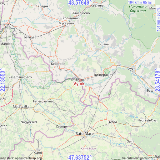
Vylok GPS coordinates[2]
48° 6' 32.94" North, 22° 50' 19.14" East
| Map corner | latitude | longitude |
|---|---|---|
| Upper-left | 48.57649°, | 22.13553° |
| Center: | 48.10915°, | 22.83865° |
| Lower-right: | 47.63752°, | 23.54178° |
| Map W x H: | 104.4×104.4 km | = 64.9×64.9mi |
| max Lat: | 52.18903° ⇑54.7% North |
| Vylok: | 48.10915° |
| min Lat: | ⇓45.3% South 44.39214° |
| min Long | Vylok | max Long |
| 22.20555° | 22.83865° | 40.13222° |
| W 1.4%⇐ | ⇒98.6% E |
Elevation
Elevation of Vylok is 117 m = 384 ft, and this is 38.8 m = 127 ft below average elevation for this country.
| Max E: |
886 m = 2907 ft | 56.1% |
| Avg. | 155.8 m = 511 ft | |
| Vylok | 117 m = 384 ft | |
Min E: |
-3 m = -10 ft | 43.9% |
See also: Ukraine elevation on elevation.city.
Geographical zone
Vylok is located in North temperate zone (between Tropic of Cancer and the Arctic Circle). Distance of this North polar circle is 2051.9 km =1275 mi to North.| Distance of | km | miles | from Vylok |
|---|---|---|---|
| North Pole | 4657.8 | 2894.2 | to North |
| Arctic Circle | 2051.9 | 1275 | to North |
| Tropic Cancer | 2743.3 | 1704.6 | to South |
| Equator | 5349.2 | 3323.8 | to South |


Nearby cities:
15 places around Vylok: (largest is in red/bold)
• Berehove
18 km =11.2 mi,  306°
306°
• Bilky
31.6 km =19.6 mi,  43°
43°
• Bobovo
6 km =3.7 mi,  134°
134°
• Chetfalva
3.8 km =2.4 mi,  299°
299°
• Irshava
27.4 km =17 mi,  32°
32°
• Korolevo
22.6 km =14 mi,  77°
77°
• Koson’
32.7 km =20.3 mi, 299°
• Kryva
30.3 km =18.8 mi, 76°
• Muzhiyevo
13 km =8.1 mi, 307°
• Oleshnyk
11 km =6.8 mi,  56°
56°
• Pidvynohradiv
10.5 km =6.5 mi,  71°
71°
• Rokosovo
27.4 km =17 mi, 65°
• Vary
9.5 km =5.9 mi,  278°
278°
• Velyki Berehy
15.3 km =9.5 mi,  333°
333°
• Vynohradiv
14.4 km =8.9 mi, 75°
Sources, notices
• [Note1] Compared only with cities in Ukraine existing in our database
• [Src1] Map data: © OpenStreetMap contributors (CC-BY-SA)
• [Src2] Other city data from geonames.org with taken over terms of usage.
• [Src3] Geographical zone / Annual Mean Temperature by Robert A. Rohde @ Wikipedia
