Chornoliztsi geodata
Chornoliztsi (Ivano-Frankivsk) is a populated place; located in Ukraine in Europe/Kiev (GMT+3) time zone. With population of 2,965 people, there are 953 cities with bigger population in this country. Compared to other cities in Ukraine, 62.7% of cities are located further ↓South; 86.7% of cities are located further →East and 81.9% of cities have lower elevation than Chornoliztsi. Note1


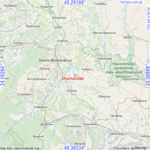
Chornoliztsi GPS coordinates[2]
48° 49' 49.224" North, 24° 53' 44.736" East
| Map corner | latitude | longitude |
|---|---|---|
| Upper-left | 49.29106°, | 24.19264° |
| Center: | 48.83034°, | 24.89576° |
| Lower-right: | 48.36534°, | 25.59889° |
| Map W x H: | 102.9×102.9 km | = 63.9×63.9mi |
| max Lat: | 52.18903° ⇑37.3% North |
| Chornoliztsi: | 48.83034° |
| min Lat: | ⇓62.7% South 44.39214° |
| min Long | Chornoliztsi | max Long |
| 22.20555° | 24.89576° | 40.13222° |
| W 13.3%⇐ | ⇒86.7% E |
Elevation
Elevation of Chornoliztsi is 258 m = 846 ft, and this is 102.2 m = 335 ft above average elevation for this country.
| Max E: |
886 m = 2907 ft | 18.1% |
| Chornoliztsi | 258 m 846 ft | |
| Avg. | 155.8 m = 511 ft | |
Min E: |
-3 m = -10 ft | 81.9% |
See also: Ukraine elevation on elevation.city.
Geographical zone
Chornoliztsi is located in North temperate zone (between Tropic of Cancer and the Arctic Circle). Distance of this North polar circle is 1971.7 km =1225.2 mi to North.| Distance of | km | miles | from Chornoliztsi |
|---|---|---|---|
| North Pole | 4577.6 | 2844.4 | to North |
| Arctic Circle | 1971.7 | 1225.2 | to North |
| Tropic Cancer | 2823.5 | 1754.4 | to South |
| Equator | 5429.4 | 3373.7 | to South |


Nearby cities:
15 places around Chornoliztsi: (largest is in red/bold)
• Bohorodchany
26.3 km =16.3 mi,  264°
264°
• Cherniyiv
13.6 km =8.5 mi,  282°
282°
• Hvizd
30 km =18.6 mi,  237°
237°
• Ivano-Frankivsk
17 km =10.6 mi,  306°
306°
• Obertyn
24.8 km =15.4 mi,  125°
125°
• Otyniya
10.6 km =6.6 mi,  193°
193°
• Radcha
17.8 km =11.1 mi, 277°
• Sadzhavka
30.4 km =18.9 mi,  195°
195°
• Stari Bohorodchany
27.2 km =16.9 mi,  270°
270°
• Tlumach
8.7 km =5.4 mi,  64°
64°
• Tysmenychany
18 km =11.2 mi,  248°
248°
• Tysmenytsya
8.8 km =5.5 mi,  334°
334°
• Uhryniv
20.3 km =12.6 mi, 313°
• Yamnytsya
22.4 km =13.9 mi,  322°
322°
• Zahvizdya
20.3 km =12.6 mi,  298°
298°
Sources, notices
• [Note1] Compared only with cities in Ukraine existing in our database
• [Src1] Map data: © OpenStreetMap contributors (CC-BY-SA)
• [Src2] Other city data from geonames.org with taken over terms of usage.
• [Src3] Geographical zone / Annual Mean Temperature by Robert A. Rohde @ Wikipedia
