Otyniya geodata
Otyniya (Ivano-Frankivsk) is a populated place; located in Ukraine in Europe/Kiev (GMT+3) time zone. With population of 5,205 people, there are 632 cities with bigger population in this country. Compared to other cities in Ukraine, 61.2% of cities are located further ↓South; 86.9% of cities are located further →East and 86.7% of cities have lower elevation than Otyniya. Note1


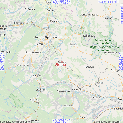
Otyniya GPS coordinates[2]
48° 44' 15.612" North, 24° 51' 39.996" East
| Map corner | latitude | longitude |
|---|---|---|
| Upper-left | 49.19925°, | 24.15799° |
| Center: | 48.73767°, | 24.86111° |
| Lower-right: | 48.27181°, | 25.56424° |
| Map W x H: | 103.1×103.1 km | = 64.1×64.1mi |
| max Lat: | 52.18903° ⇑38.8% North |
| Otyniya: | 48.73767° |
| min Lat: | ⇓61.2% South 44.39214° |
| min Long | Otyniya | max Long |
| 22.20555° | 24.86111° | 40.13222° |
| W 13.1%⇐ | ⇒86.9% E |
Elevation
Elevation of Otyniya is 284 m = 932 ft, and this is 128.2 m = 421 ft above average elevation for this country.
| Max E: |
886 m = 2907 ft | 13.3% |
| Otyniya | 284 m 932 ft | |
| Avg. | 155.8 m = 511 ft | |
Min E: |
-3 m = -10 ft | 86.7% |
See also: Ukraine elevation on elevation.city.
Geographical zone
Otyniya is located in North temperate zone (between Tropic of Cancer and the Arctic Circle). Distance of this North polar circle is 1982.1 km =1231.6 mi to North.| Distance of | km | miles | from Otyniya |
|---|---|---|---|
| North Pole | 4587.9 | 2850.8 | to North |
| Arctic Circle | 1982.1 | 1231.6 | to North |
| Tropic Cancer | 2813.2 | 1748 | to South |
| Equator | 5419.1 | 3367.3 | to South |


Nearby cities:
15 places around Otyniya: (largest is in red/bold)
• Bohorodchany
24.9 km =15.5 mi,  288°
288°
• Cherniyiv
17.1 km =10.6 mi,  320°
320°
• Chornoliztsi
10.6 km =6.6 mi,  13°
13°
• Hvizd
23.5 km =14.6 mi,  255°
255°
• Ivano-Frankivsk
23.3 km =14.5 mi,  331°
331°
• Krasna
21.5 km =13.4 mi,  213°
213°
• Lanchyn
21.4 km =13.3 mi,  201°
201°
• Nadvirna
24.3 km =15.1 mi,  241°
241°
• Obertyn
23 km =14.3 mi,  100°
100°
• Pechenizhyn
24.8 km =15.4 mi,  174°
174°
• Radcha
19.6 km =12.2 mi,  309°
309°
• Sadzhavka
19.8 km =12.3 mi, 195°
• Tlumach
17.5 km =10.9 mi,  36°
36°
• Tysmenychany
14.8 km =9.2 mi,  284°
284°
• Tysmenytsya
18.3 km =11.4 mi,  356°
356°
Sources, notices
• [Note1] Compared only with cities in Ukraine existing in our database
• [Src1] Map data: © OpenStreetMap contributors (CC-BY-SA)
• [Src2] Other city data from geonames.org with taken over terms of usage.
• [Src3] Geographical zone / Annual Mean Temperature by Robert A. Rohde @ Wikipedia
