Boykivske geodata
Boykivske (Donetsk) is a seat of a second-order administrative division; located in Ukraine in Europe/Kiev (GMT+3) time zone. With population of 4,423 people, there are 709 cities with bigger population in this country. Compared to other cities in Ukraine, 61.3% of cities are located further ↑North; 94.5% of cities are located further ←West and 60.6% of cities have higher elevation than Boykivske. Note1


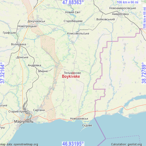
Boykivske GPS coordinates[2]
47° 24' 35.784" North, 38° 1' 29.136" East
| Map corner | latitude | longitude |
|---|---|---|
| Upper-left | 47.88363°, | 37.32164° |
| Center: | 47.40994°, | 38.02476° |
| Lower-right: | 46.93195°, | 38.72789° |
| Map W x H: | 105.8×105.8 km | = 65.7×65.7mi |
| max Lat: | 52.18903° ⇑61.3% North |
| Boykivske: | 47.40994° |
| min Lat: | ⇓38.7% South 44.39214° |
| min Long | Boykivske | max Long |
| 22.20555° | 38.02476° | 40.13222° |
| W 94.5%⇐ | ⇒5.5% E |
Elevation
Elevation of Boykivske is 104 m = 341 ft, and this is 51.8 m = 170 ft below average elevation for this country.
| Max E: |
886 m = 2907 ft | 60.6% |
| Avg. | 155.8 m = 511 ft | |
| Boykivske | 104 m = 341 ft | |
Min E: |
-3 m = -10 ft | 39.4% |
See also: Ukraine elevation on elevation.city.
Geographical zone
Boykivske is located in North temperate zone (between Tropic of Cancer and the Arctic Circle). Distance of this North polar circle is 2129.7 km =1323.3 mi to North.| Distance of | km | miles | from Boykivske |
|---|---|---|---|
| North Pole | 4735.6 | 2942.6 | to North |
| Arctic Circle | 2129.7 | 1323.3 | to North |
| Tropic Cancer | 2665.6 | 1656.3 | to South |
| Equator | 5271.5 | 3275.6 | to South |


Nearby cities:
15 places around Boykivske: (largest is in red/bold)
• Bezimenne
34.3 km =21.3 mi,  190°
190°
• Dianivka
47.2 km =29.3 mi,  271°
271°
• Dokuchayevs’k
45.9 km =28.5 mi,  325°
325°
• Horbachevo-Mykhaylivka
49.1 km =30.5 mi,  358°
358°
• Kalynove
42.5 km =26.4 mi,  277°
277°
• Kuteynykove
48.9 km =30.4 mi,  23°
23°
• Kuznetsovo-Mykhaylivka
15.2 km =9.4 mi,  69°
69°
• Novoazovs'k
33.2 km =20.6 mi,  172°
172°
• Novyy Svit
44 km =27.3 mi, 359°
• Pikuzy
30.7 km =19.1 mi,  211°
211°
• Sartana
36.2 km =22.5 mi,  223°
223°
• Starobesheve
37.9 km =23.5 mi,  0°
0°
• Staryy Krym
48.9 km =30.4 mi,  235°
235°
• Syedove
38.3 km =23.8 mi, 165°
• Volnovakha
45 km =28 mi,  298°
298°
In other languages:
- In France: Boïkivske
- In German: Bojkiwske, Telmanowe, Ostheim
- In Russian: Tel’manovo, Тельманово
- In Chinese: 捷利馬諾韋
Sources, notices
• [Note1] Compared only with cities in Ukraine existing in our database
• [Src1] Map data: © OpenStreetMap contributors (CC-BY-SA)
• [Src2] Other city data from geonames.org with taken over terms of usage.
• [Src3] Geographical zone / Annual Mean Temperature by Robert A. Rohde @ Wikipedia
