Staryy Saltiv geodata
Staryy Saltiv (Kharkiv) is a populated place; located in Ukraine in Europe/Kiev (GMT+3) time zone. With population of 3,776 people, there are 788 cities with bigger population in this country. Compared to other cities in Ukraine, 84.9% of cities are located further ↓South; 90.4% of cities are located further ←West and 59.4% of cities have higher elevation than Staryy Saltiv. Note1


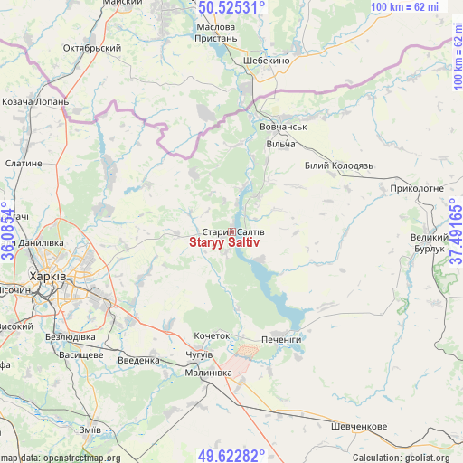
Staryy Saltiv GPS coordinates[2]
50° 4' 34.284" North, 36° 47' 18.672" East
| Map corner | latitude | longitude |
|---|---|---|
| Upper-left | 50.52531°, | 36.0854° |
| Center: | 50.07619°, | 36.78852° |
| Lower-right: | 49.62282°, | 37.49165° |
| Map W x H: | 100.3×100.3 km | = 62.3×62.3mi |
| max Lat: | 52.18903° ⇑15.1% North |
| Staryy Saltiv: | 50.07619° |
| min Lat: | ⇓84.9% South 44.39214° |
| min Long | Staryy Saltiv | max Long |
| 22.20555° | 36.78852° | 40.13222° |
| W 90.4%⇐ | ⇒9.6% E |
Elevation
Elevation of Staryy Saltiv is 107 m = 351 ft, and this is 48.8 m = 160 ft below average elevation for this country.
| Max E: |
886 m = 2907 ft | 59.4% |
| Avg. | 155.8 m = 511 ft | |
| Staryy Saltiv | 107 m = 351 ft | |
Min E: |
-3 m = -10 ft | 40.6% |
See also: Ukraine elevation on elevation.city.
Geographical zone
Staryy Saltiv is located in North temperate zone (between Tropic of Cancer and the Arctic Circle). Distance of this North polar circle is 1833.2 km =1139.1 mi to North.| Distance of | km | miles | from Staryy Saltiv |
|---|---|---|---|
| North Pole | 4439.1 | 2758.3 | to North |
| Arctic Circle | 1833.2 | 1139.1 | to North |
| Tropic Cancer | 2962 | 1840.5 | to South |
| Equator | 5568 | 3459.8 | to South |


Nearby cities:
15 places around Staryy Saltiv: (largest is in red/bold)
• Bezlyudivka
43.6 km =27.1 mi,  239°
239°
• Chuhuyiv
27.7 km =17.2 mi,  195°
195°
• Eskhar
34.2 km =21.3 mi, 204°
• Kharkiv
39.7 km =24.7 mi,  254°
254°
• Kochetok
22.1 km =13.7 mi,  189°
189°
• Kulynychi
30.8 km =19.1 mi, 250°
• Mala Danylivka
44.5 km =27.7 mi,  268°
268°
• Malynivka
29.1 km =18.1 mi, 187°
• Novopokrovka
32 km =19.9 mi,  212°
212°
• Pechenihy
25 km =15.5 mi,  155°
155°
• Prykolotne
40.8 km =25.4 mi,  76°
76°
• Vasyshcheve
43 km =26.7 mi,  230°
230°
• Velykyy Burluk
42.5 km =26.4 mi,  92°
92°
• Vovchans’k
26.2 km =16.3 mi,  24°
24°
• Vvedenka
34.7 km =21.6 mi,  216°
216°
Sources, notices
• [Note1] Compared only with cities in Ukraine existing in our database
• [Src1] Map data: © OpenStreetMap contributors (CC-BY-SA)
• [Src2] Other city data from geonames.org with taken over terms of usage.
• [Src3] Geographical zone / Annual Mean Temperature by Robert A. Rohde @ Wikipedia
