Prykolotne geodata
Prykolotne (Kharkiv) is a populated place; located in Ukraine in Europe/Kiev (GMT+3) time zone. With population of 2,499 people, there are 1037 cities with bigger population in this country. Compared to other cities in Ukraine, 86% of cities are located further ↓South; 91.9% of cities are located further ←West and 71.8% of cities have lower elevation than Prykolotne. Note1


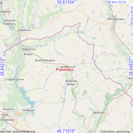
Prykolotne GPS coordinates[2]
50° 9' 45.828" North, 37° 20' 42.864" East
| Map corner | latitude | longitude |
|---|---|---|
| Upper-left | 50.61104°, | 36.64212° |
| Center: | 50.16273°, | 37.34524° |
| Lower-right: | 49.71018°, | 38.04837° |
| Map W x H: | 100.2×100.2 km | = 62.3×62.3mi |
| max Lat: | 52.18903° ⇑14% North |
| Prykolotne: | 50.16273° |
| min Lat: | ⇓86% South 44.39214° |
| min Long | Prykolotne | max Long |
| 22.20555° | 37.34524° | 40.13222° |
| W 91.9%⇐ | ⇒8.1% E |
Elevation
Elevation of Prykolotne is 213 m = 699 ft, and this is 57.2 m = 188 ft above average elevation for this country.
| Max E: |
886 m = 2907 ft | 28.2% |
| Prykolotne | 213 m 699 ft | |
| Avg. | 155.8 m = 511 ft | |
Min E: |
-3 m = -10 ft | 71.8% |
See also: Ukraine elevation on elevation.city.
Geographical zone
Prykolotne is located in North temperate zone (between Tropic of Cancer and the Arctic Circle). Distance of this North polar circle is 1823.6 km =1133.1 mi to North.| Distance of | km | miles | from Prykolotne |
|---|---|---|---|
| North Pole | 4429.5 | 2752.4 | to North |
| Arctic Circle | 1823.6 | 1133.1 | to North |
| Tropic Cancer | 2971.7 | 1846.5 | to South |
| Equator | 5577.6 | 3465.8 | to South |


Nearby cities:
15 places around Prykolotne: (largest is in red/bold)
• Chuhuyiv
59.4 km =36.9 mi,  232°
232°
• Dvorichna
42.3 km =26.3 mi,  145°
145°
• Eskhar
67.6 km =42 mi, 232°
• Kivsharivka
64 km =39.8 mi,  157°
157°
• Kochetok
53.6 km =33.3 mi, 234°
• Kulynychi
71.6 km =44.5 mi,  253°
253°
• Kupjansk
53.9 km =33.5 mi, 158°
• Malynivka
58.3 km =36.2 mi, 228°
• Novopokrovka
67.7 km =42.1 mi,  237°
237°
• Pechenihy
43.7 km =27.2 mi,  222°
222°
• Shevchenkove
53.3 km =33.1 mi,  193°
193°
• Staryy Saltiv
40.8 km =25.4 mi,  256°
256°
• Velykyy Burluk
11.6 km =7.2 mi,  166°
166°
• Vovchans’k
32.1 km =19.9 mi,  296°
296°
• Vvedenka
71.1 km =44.2 mi, 237°
Sources, notices
• [Note1] Compared only with cities in Ukraine existing in our database
• [Src1] Map data: © OpenStreetMap contributors (CC-BY-SA)
• [Src2] Other city data from geonames.org with taken over terms of usage.
• [Src3] Geographical zone / Annual Mean Temperature by Robert A. Rohde @ Wikipedia
