Shabo geodata
Shabo (Odesa) is a populated place; located in Ukraine in Europe/Kiev (GMT+3) time zone. With population of 6,886 people, there are 519 cities with bigger population in this country. Compared to other cities in Ukraine, 68.9% of cities are located further ↑North; 65.3% of cities are located further →East and 93% of cities have higher elevation than Shabo. Note1


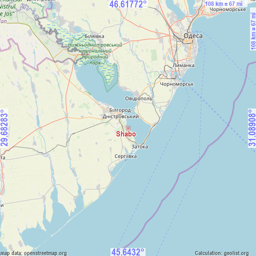
Shabo GPS coordinates[2]
46° 7' 57.432" North, 30° 23' 9.42" East
| Map corner | latitude | longitude |
|---|---|---|
| Upper-left | 46.61772°, | 29.68283° |
| Center: | 46.13262°, | 30.38595° |
| Lower-right: | 45.6432°, | 31.08908° |
| Map W x H: | 108.4×108.4 km | = 67.4×67.4mi |
| max Lat: | 52.18903° ⇑68.9% North |
| Shabo: | 46.13262° |
| min Lat: | ⇓31.1% South 44.39214° |
| min Long | Shabo | max Long |
| 22.20555° | 30.38595° | 40.13222° |
| W 34.7%⇐ | ⇒65.3% E |
Elevation
Elevation of Shabo is 15 m = 49 ft, and this is 140.8 m = 462 ft below average elevation for this country.
| Max E: |
886 m = 2907 ft | 93% |
| Avg. | 155.8 m = 511 ft | |
| Shabo | 15 m = 49 ft | |
Min E: |
-3 m = -10 ft | 7% |
See also: Ukraine elevation on elevation.city.
Geographical zone
Shabo is located in North temperate zone (between Tropic of Cancer and the Arctic Circle). Distance of this North polar circle is 2271.7 km =1411.6 mi to North.| Distance of | km | miles | from Shabo |
|---|---|---|---|
| North Pole | 4877.6 | 3030.8 | to North |
| Arctic Circle | 2271.7 | 1411.6 | to North |
| Tropic Cancer | 2523.5 | 1568 | to South |
| Equator | 5129.5 | 3187.3 | to South |


Nearby cities:
15 places around Shabo: (largest is in red/bold)
• Bilhorod-Dnistrovskyi
7.5 km =4.7 mi,  337°
337°
• Bilyayivka
41.1 km =25.5 mi, 341°
• Chornomors’k
28.2 km =17.5 mi,  47°
47°
• Kamyshevka Vtoraya
44 km =27.3 mi,  284°
284°
• Karolino-Buhaz
10.9 km =6.8 mi,  82°
82°
• Kulevcha
36.5 km =22.7 mi,  251°
251°
• Mayaky
32.8 km =20.4 mi, 344°
• Oleksandrivka
29 km =18 mi,  41°
41°
• Ovidiopol
13.7 km =8.5 mi,  18°
18°
• Salhany
3.6 km =2.2 mi,  300°
300°
• Serhiyivka
11.7 km =7.3 mi,  183°
183°
• Starokozache
38.3 km =23.8 mi,  306°
306°
• Tayirove
32.6 km =20.3 mi, 38°
• Teplodar
41.8 km =26 mi,  353°
353°
• Zatoka
9.1 km =5.7 mi,  137°
137°
Sources, notices
• [Note1] Compared only with cities in Ukraine existing in our database
• [Src1] Map data: © OpenStreetMap contributors (CC-BY-SA)
• [Src2] Other city data from geonames.org with taken over terms of usage.
• [Src3] Geographical zone / Annual Mean Temperature by Robert A. Rohde @ Wikipedia
