Mayaky geodata
Mayaky (Odesa) is a populated place; located in Ukraine in Europe/Kiev (GMT+3) time zone. With population of 5,937 people, there are 573 cities with bigger population in this country. Compared to other cities in Ukraine, 67.5% of cities are located further ↑North; 66.2% of cities are located further →East and 92.2% of cities have higher elevation than Mayaky. Note1


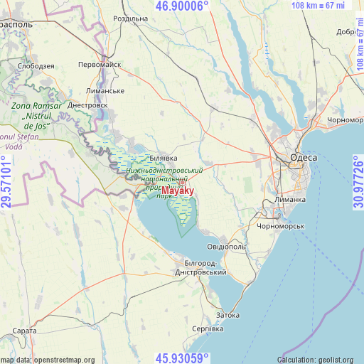
Mayaky GPS coordinates[2]
46° 25' 2.928" North, 30° 16' 26.868" East
| Map corner | latitude | longitude |
|---|---|---|
| Upper-left | 46.90006°, | 29.57101° |
| Center: | 46.41748°, | 30.27413° |
| Lower-right: | 45.93059°, | 30.97726° |
| Map W x H: | 107.8×107.8 km | = 67×67mi |
| max Lat: | 52.18903° ⇑67.5% North |
| Mayaky: | 46.41748° |
| min Lat: | ⇓32.5% South 44.39214° |
| min Long | Mayaky | max Long |
| 22.20555° | 30.27413° | 40.13222° |
| W 33.8%⇐ | ⇒66.2% E |
Elevation
Elevation of Mayaky is 16 m = 52 ft, and this is 139.8 m = 459 ft below average elevation for this country.
| Max E: |
886 m = 2907 ft | 92.2% |
| Avg. | 155.8 m = 511 ft | |
| Mayaky | 16 m = 52 ft | |
Min E: |
-3 m = -10 ft | 7.8% |
See also: Ukraine elevation on elevation.city.
Geographical zone
Mayaky is located in North temperate zone (between Tropic of Cancer and the Arctic Circle). Distance of this North polar circle is 2240 km =1391.9 mi to North.| Distance of | km | miles | from Mayaky |
|---|---|---|---|
| North Pole | 4845.9 | 3011.1 | to North |
| Arctic Circle | 2240 | 1391.9 | to North |
| Tropic Cancer | 2555.2 | 1587.7 | to South |
| Equator | 5161.1 | 3207 | to South |


Nearby cities:
15 places around Mayaky: (largest is in red/bold)
• Bilhorod-Dnistrovskyi
25.4 km =15.8 mi,  166°
166°
• Bilyayivka
8.5 km =5.3 mi,  328°
328°
• Chornomors’k
31.8 km =19.8 mi,  113°
113°
• Karolino-Buhaz
36 km =22.4 mi,  147°
147°
• Lymanske
35.4 km =22 mi,  318°
318°
• Odessa
35.8 km =22.2 mi,  79°
79°
• Oleksandrivka
29.4 km =18.3 mi, 109°
• Ovidiopol
22.6 km =14 mi, 145°
• Salhany
30.4 km =18.9 mi, 169°
• Shabo
32.8 km =20.4 mi,  164°
164°
• Starokozache
23.9 km =14.9 mi,  248°
248°
• Stepove
35.2 km =21.9 mi, 334°
• Tayirove
29.4 km =18.3 mi,  101°
101°
• Teplodar
10.6 km =6.6 mi,  21°
21°
• Usatove
32.2 km =20 mi,  66°
66°
Sources, notices
• [Note1] Compared only with cities in Ukraine existing in our database
• [Src1] Map data: © OpenStreetMap contributors (CC-BY-SA)
• [Src2] Other city data from geonames.org with taken over terms of usage.
• [Src3] Geographical zone / Annual Mean Temperature by Robert A. Rohde @ Wikipedia
