Blahodatne geodata
Blahodatne (Donetsk) is a populated place; located in Ukraine in Europe/Kiev (GMT+3) time zone. With population of 1,263 people, there are 1277 cities with bigger population in this country. Compared to other cities in Ukraine, 59.1% of cities are located further ↑North; 92.2% of cities are located further ←West and 71.5% of cities have lower elevation than Blahodatne. Note1


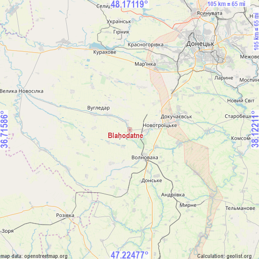
Blahodatne GPS coordinates[2]
47° 42' 0.468" North, 37° 25' 8.328" East
| Map corner | latitude | longitude |
|---|---|---|
| Upper-left | 48.17119°, | 36.71586° |
| Center: | 47.70013°, | 37.41898° |
| Lower-right: | 47.22477°, | 38.12211° |
| Map W x H: | 105.2×105.2 km | = 65.4×65.4mi |
| max Lat: | 52.18903° ⇑59.1% North |
| Blahodatne: | 47.70013° |
| min Lat: | ⇓40.9% South 44.39214° |
| min Long | Blahodatne | max Long |
| 22.20555° | 37.41898° | 40.13222° |
| W 92.2%⇐ | ⇒7.8% E |
Elevation
Elevation of Blahodatne is 212 m = 696 ft, and this is 56.2 m = 184 ft above average elevation for this country.
| Max E: |
886 m = 2907 ft | 28.5% |
| Blahodatne | 212 m 696 ft | |
| Avg. | 155.8 m = 511 ft | |
Min E: |
-3 m = -10 ft | 71.5% |
See also: Ukraine elevation on elevation.city.
Geographical zone
Blahodatne is located in North temperate zone (between Tropic of Cancer and the Arctic Circle). Distance of this North polar circle is 2097.4 km =1303.3 mi to North.| Distance of | km | miles | from Blahodatne |
|---|---|---|---|
| North Pole | 4703.3 | 2922.5 | to North |
| Arctic Circle | 2097.4 | 1303.3 | to North |
| Tropic Cancer | 2697.8 | 1676.3 | to South |
| Equator | 5303.8 | 3295.6 | to South |


Nearby cities:
15 places around Blahodatne: (largest is in red/bold)
• Dianivka
30.9 km =19.2 mi,  182°
182°
• Dokuchayevs’k
20.3 km =12.6 mi,  73°
73°
• Donetsk
45.9 km =28.5 mi,  38°
38°
• Horbachevo-Mykhaylivka
47 km =29.2 mi, 69°
• Kalynove
27.2 km =16.9 mi,  172°
172°
• Kurakhovo
33.3 km =20.7 mi,  342°
342°
• Makiyivka
54.1 km =33.6 mi, 44°
• Mar'yinka
28 km =17.4 mi,  13°
13°
• Mospyne
52.6 km =32.7 mi, 66°
• Novyy Svit
46.5 km =28.9 mi,  75°
75°
• Rozivka
43.9 km =27.3 mi,  216°
216°
• Selydove
50.5 km =31.4 mi,  349°
349°
• Starobesheve
46.1 km =28.6 mi, 83°
• Velyka Novosilka
46.5 km =28.9 mi,  290°
290°
• Volnovakha
12.5 km =7.8 mi,  152°
152°
Sources, notices
• [Note1] Compared only with cities in Ukraine existing in our database
• [Src1] Map data: © OpenStreetMap contributors (CC-BY-SA)
• [Src2] Other city data from geonames.org with taken over terms of usage.
• [Src3] Geographical zone / Annual Mean Temperature by Robert A. Rohde @ Wikipedia
