Duliby geodata
Duliby (Lviv) is a populated place; located in Ukraine in Europe/Kiev (GMT+3) time zone. With population of 3,533 people, there are 827 cities with bigger population in this country. Compared to other cities in Ukraine, 70.3% of cities are located further ↓South; 94.1% of cities are located further →East and 89.9% of cities have lower elevation than Duliby. Note1


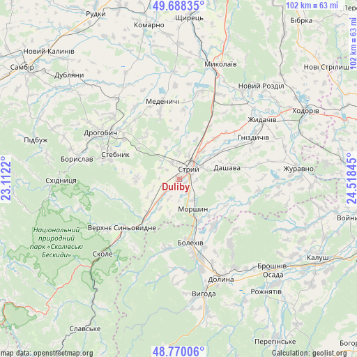
Duliby GPS coordinates[2]
49° 13' 52.824" North, 23° 48' 55.152" East
| Map corner | latitude | longitude |
|---|---|---|
| Upper-left | 49.68835°, | 23.1122° |
| Center: | 49.23134°, | 23.81532° |
| Lower-right: | 48.77006°, | 24.51845° |
| Map W x H: | 102.1×102.1 km | = 63.4×63.4mi |
| max Lat: | 52.18903° ⇑29.7% North |
| Duliby: | 49.23134° |
| min Lat: | ⇓70.3% South 44.39214° |
| min Long | Duliby | max Long |
| 22.20555° | 23.81532° | 40.13222° |
| W 5.9%⇐ | ⇒94.1% E |
Elevation
Elevation of Duliby is 306 m = 1004 ft, and this is 150.2 m = 493 ft above average elevation for this country.
| Max E: |
886 m = 2907 ft | 10.1% |
| Duliby | 306 m 1004 ft | |
| Avg. | 155.8 m = 511 ft | |
Min E: |
-3 m = -10 ft | 89.9% |
See also: Ukraine elevation on elevation.city.
Geographical zone
Duliby is located in North temperate zone (between Tropic of Cancer and the Arctic Circle). Distance of this North polar circle is 1927.2 km =1197.5 mi to North.| Distance of | km | miles | from Duliby |
|---|---|---|---|
| North Pole | 4533.1 | 2816.7 | to North |
| Arctic Circle | 1927.2 | 1197.5 | to North |
| Tropic Cancer | 2868.1 | 1782.2 | to South |
| Equator | 5474 | 3401.4 | to South |


Nearby cities:
15 places around Duliby: (largest is in red/bold)
• Bolekhiv
18.7 km =11.6 mi,  169°
169°
• Boryslav
28.5 km =17.7 mi,  282°
282°
• Drohobych
26 km =16.2 mi,  300°
300°
• Medenychi
22.6 km =14 mi,  348°
348°
• Morshyn
9.3 km =5.8 mi,  153°
153°
• Rozdil
31.2 km =19.4 mi,  34°
34°
• Rykhtychi
25.4 km =15.8 mi,  312°
312°
• Skole
30.8 km =19.1 mi,  225°
225°
• Stebnyk
19.6 km =12.2 mi,  290°
290°
• Stryi
4.5 km =2.8 mi,  40°
40°
• Truskavets’
23 km =14.3 mi, 283°
• Ulychne
11.9 km =7.4 mi,  271°
271°
• Verkhnie Synevydne
21.7 km =13.5 mi, 228°
• Zhydachiv
29.2 km =18.1 mi,  54°
54°
• Розгирче
15.2 km =9.4 mi,  217°
217°
Sources, notices
• [Note1] Compared only with cities in Ukraine existing in our database
• [Src1] Map data: © OpenStreetMap contributors (CC-BY-SA)
• [Src2] Other city data from geonames.org with taken over terms of usage.
• [Src3] Geographical zone / Annual Mean Temperature by Robert A. Rohde @ Wikipedia
