Novi Strilyscha geodata
Novi Strilyscha (Lviv) is a populated place; located in Ukraine in Europe/Kiev (GMT+3) time zone. With population of 938 people, there are 1410 cities with bigger population in this country. Compared to other cities in Ukraine, 74.5% of cities are located further ↓South; 90% of cities are located further →East and 92.7% of cities have lower elevation than Novi Strilyscha. Note1


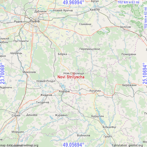
Novi Strilyscha GPS coordinates[2]
49° 30' 56.052" North, 24° 24' 13.716" East
| Map corner | latitude | longitude |
|---|---|---|
| Upper-left | 49.96994°, | 23.70069° |
| Center: | 49.51557°, | 24.40381° |
| Lower-right: | 49.05694°, | 25.10694° |
| Map W x H: | 101.5×101.5 km | = 63.1×63.1mi |
| max Lat: | 52.18903° ⇑25.5% North |
| Novi Strilyscha: | 49.51557° |
| min Lat: | ⇓74.5% South 44.39214° |
| min Long | Novi Strilyscha | max Long |
| 22.20555° | 24.40381° | 40.13222° |
| W 10%⇐ | ⇒90% E |
Elevation
Elevation of Novi Strilyscha is 327 m = 1073 ft, and this is 171.2 m = 562 ft above average elevation for this country.
| Max E: |
886 m = 2907 ft | 7.3% |
| Novi Strilyscha | 327 m 1073 ft | |
| Avg. | 155.8 m = 511 ft | |
Min E: |
-3 m = -10 ft | 92.7% |
See also: Ukraine elevation on elevation.city.
Geographical zone
Novi Strilyscha is located in North temperate zone (between Tropic of Cancer and the Arctic Circle). Distance of this North polar circle is 1895.6 km =1177.9 mi to North.| Distance of | km | miles | from Novi Strilyscha |
|---|---|---|---|
| North Pole | 4501.4 | 2797 | to North |
| Arctic Circle | 1895.6 | 1177.9 | to North |
| Tropic Cancer | 2899.7 | 1801.8 | to South |
| Equator | 5505.6 | 3421 | to South |


Nearby cities:
15 places around Novi Strilyscha: (largest is in red/bold)
• Bibrka
16.2 km =10.1 mi,  329°
329°
• Chesniki
27.3 km =17 mi,  121°
121°
• Dunayiv
32.4 km =20.1 mi,  69°
69°
• Dzvinogrud
26.6 km =16.5 mi,  335°
335°
• Khodoriv
13.8 km =8.6 mi,  211°
211°
• Mykolaiv
30.2 km =18.8 mi,  271°
271°
• Peremyshlyany
20 km =12.4 mi,  33°
33°
• Rohatyn
19 km =11.8 mi,  128°
128°
• Rozdil
25.4 km =15.8 mi,  256°
256°
• Rozvadiv
31.9 km =19.8 mi, 267°
• Shpyl’chyna
18.7 km =11.6 mi, 331°
• Staroye Selo
26.6 km =16.5 mi,  324°
324°
• Svirzh
15 km =9.3 mi,  9°
9°
• Vyshnivchyk
32.1 km =19.9 mi,  50°
50°
• Zhydachiv
23.8 km =14.8 mi,  232°
232°
Sources, notices
• [Note1] Compared only with cities in Ukraine existing in our database
• [Src1] Map data: © OpenStreetMap contributors (CC-BY-SA)
• [Src2] Other city data from geonames.org with taken over terms of usage.
• [Src3] Geographical zone / Annual Mean Temperature by Robert A. Rohde @ Wikipedia
