Hirs’ke geodata
Hirs’ke (Luhansk) is a populated place; located in Ukraine in Europe/Zaporozhye (GMT+3) time zone. With population of 11,046 people, there are 326 cities with bigger population in this country. Compared to other cities in Ukraine, 61.1% of cities are located further ↓South; 96.8% of cities are located further ←West and 70.3% of cities have lower elevation than Hirs’ke. Note1


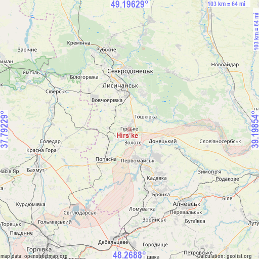
Hirs’ke GPS coordinates[2]
48° 44' 4.848" North, 38° 29' 43.476" East
| Map corner | latitude | longitude |
|---|---|---|
| Upper-left | 49.19629°, | 37.79229° |
| Center: | 48.73468°, | 38.49541° |
| Lower-right: | 48.2688°, | 39.19854° |
| Map W x H: | 103.1×103.1 km | = 64.1×64.1mi |
| max Lat: | 52.18903° ⇑38.9% North |
| Hirs’ke: | 48.73468° |
| min Lat: | ⇓61.1% South 44.39214° |
| min Long | Hirs’ke | max Long |
| 22.20555° | 38.49541° | 40.13222° |
| W 96.8%⇐ | ⇒3.2% E |
Elevation
Elevation of Hirs’ke is 207 m = 679 ft, and this is 51.2 m = 168 ft above average elevation for this country.
| Max E: |
886 m = 2907 ft | 29.7% |
| Hirs’ke | 207 m 679 ft | |
| Avg. | 155.8 m = 511 ft | |
Min E: |
-3 m = -10 ft | 70.3% |
See also: Ukraine elevation on elevation.city.
Geographical zone
Hirs’ke is located in North temperate zone (between Tropic of Cancer and the Arctic Circle). Distance of this North polar circle is 1982.4 km =1231.8 mi to North.| Distance of | km | miles | from Hirs’ke |
|---|---|---|---|
| North Pole | 4588.3 | 2851 | to North |
| Arctic Circle | 1982.4 | 1231.8 | to North |
| Tropic Cancer | 2812.9 | 1747.9 | to South |
| Equator | 5418.8 | 3367.1 | to South |


Nearby cities:
15 places around Hirs’ke: (largest is in red/bold)
• Bilohorivka
27.8 km =17.3 mi,  319°
319°
• Bryanka
28.1 km =17.5 mi,  152°
152°
• Kadiyivka
21.5 km =13.4 mi, 149°
• Kirovs’k
15.3 km =9.5 mi,  134°
134°
• Lysychans’k
19.3 km =12 mi,  348°
348°
• Met’olkine
22.2 km =13.8 mi,  11°
11°
• Pervomays’k
12.3 km =7.6 mi,  161°
161°
• Popasna
14.2 km =8.8 mi,  217°
217°
• Rubizhne
32 km =19.9 mi,  344°
344°
• Serebryanka
33.4 km =20.8 mi,  307°
307°
• Sivers’k
32.5 km =20.2 mi,  296°
296°
• Soledar
30.4 km =18.9 mi,  258°
258°
• Syevyerodonets’k
23.8 km =14.8 mi,  359°
359°
• Toshkivka
7.9 km =4.9 mi,  51°
51°
• Voronove
19 km =11.8 mi,  17°
17°
Sources, notices
• [Note1] Compared only with cities in Ukraine existing in our database
• [Src1] Map data: © OpenStreetMap contributors (CC-BY-SA)
• [Src2] Other city data from geonames.org with taken over terms of usage.
• [Src3] Geographical zone / Annual Mean Temperature by Robert A. Rohde @ Wikipedia
