Toshkivka geodata
Toshkivka (Luhansk) is a populated place; located in Ukraine in Europe/Zaporozhye (GMT+3) time zone. With population of 4,926 people, there are 659 cities with bigger population in this country. Compared to other cities in Ukraine, 61.7% of cities are located further ↓South; 97.1% of cities are located further ←West and 50.8% of cities have higher elevation than Toshkivka. Note1


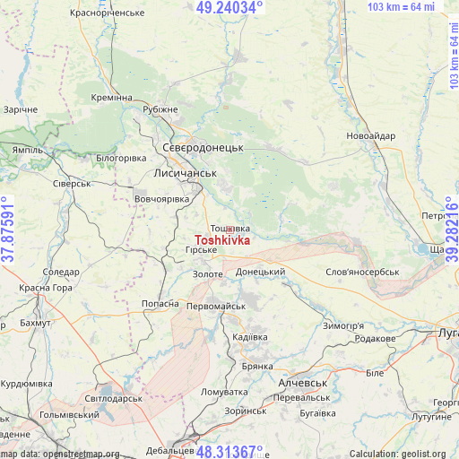
Toshkivka GPS coordinates[2]
48° 46' 44.904" North, 38° 34' 44.508" East
| Map corner | latitude | longitude |
|---|---|---|
| Upper-left | 49.24034°, | 37.87591° |
| Center: | 48.77914°, | 38.57903° |
| Lower-right: | 48.31367°, | 39.28216° |
| Map W x H: | 103×103 km | = 64×64mi |
| max Lat: | 52.18903° ⇑38.3% North |
| Toshkivka: | 48.77914° |
| min Lat: | ⇓61.7% South 44.39214° |
| min Long | Toshkivka | max Long |
| 22.20555° | 38.57903° | 40.13222° |
| W 97.1%⇐ | ⇒2.9% E |
Elevation
Elevation of Toshkivka is 131 m = 430 ft, and this is 24.8 m = 81 ft below average elevation for this country.
| Max E: |
886 m = 2907 ft | 50.8% |
| Avg. | 155.8 m = 511 ft | |
| Toshkivka | 131 m = 430 ft | |
Min E: |
-3 m = -10 ft | 49.2% |
See also: Ukraine elevation on elevation.city.
Geographical zone
Toshkivka is located in North temperate zone (between Tropic of Cancer and the Arctic Circle). Distance of this North polar circle is 1977.4 km =1228.7 mi to North.| Distance of | km | miles | from Toshkivka |
|---|---|---|---|
| North Pole | 4583.3 | 2847.9 | to North |
| Arctic Circle | 1977.4 | 1228.7 | to North |
| Tropic Cancer | 2817.8 | 1750.9 | to South |
| Equator | 5423.7 | 3370.1 | to South |


Nearby cities:
15 places around Toshkivka: (largest is in red/bold)
• Bilohorivka
29.1 km =18.1 mi,  303°
303°
• Bryanka
30.6 km =19 mi,  167°
167°
• Hirs’ke
7.9 km =4.9 mi,  231°
231°
• Kadiyivka
23.9 km =14.9 mi, 168°
• Kirovs’k
16.4 km =10.2 mi,  163°
163°
• Lysychans’k
17.2 km =10.7 mi,  324°
324°
• Met’olkine
16.9 km =10.5 mi,  353°
353°
• Pervomays’k
16.8 km =10.4 mi,  187°
187°
• Popasna
21.9 km =13.6 mi,  222°
222°
• Pryvillya
33 km =20.5 mi, 322°
• Rubizhne
29.7 km =18.5 mi,  330°
330°
• Slov`yanoserbsk
30.9 km =19.2 mi,  107°
107°
• Syevyerodonets’k
19.9 km =12.4 mi,  341°
341°
• Tr’okhizbenka
28.3 km =17.6 mi,  94°
94°
• Voronove
13.2 km =8.2 mi,  358°
358°
Sources, notices
• [Note1] Compared only with cities in Ukraine existing in our database
• [Src1] Map data: © OpenStreetMap contributors (CC-BY-SA)
• [Src2] Other city data from geonames.org with taken over terms of usage.
• [Src3] Geographical zone / Annual Mean Temperature by Robert A. Rohde @ Wikipedia
