Panyutyne geodata
Panyutyne (Kharkiv) is a populated place; located in Ukraine in Europe/Kiev (GMT+3) time zone. With population of 7,038 people, there are 505 cities with bigger population in this country. Compared to other cities in Ukraine, 64.9% of cities are located further ↓South; 88.7% of cities are located further ←West and 61% of cities have lower elevation than Panyutyne. Note1


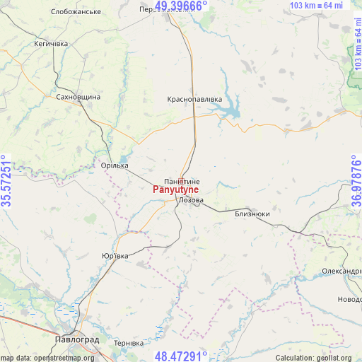
Panyutyne GPS coordinates[2]
48° 56' 12.912" North, 36° 16' 32.268" East
| Map corner | latitude | longitude |
|---|---|---|
| Upper-left | 49.39666°, | 35.57251° |
| Center: | 48.93692°, | 36.27563° |
| Lower-right: | 48.47291°, | 36.97876° |
| Map W x H: | 102.7×102.7 km | = 63.8×63.8mi |
| max Lat: | 52.18903° ⇑35.1% North |
| Panyutyne: | 48.93692° |
| min Lat: | ⇓64.9% South 44.39214° |
| min Long | Panyutyne | max Long |
| 22.20555° | 36.27563° | 40.13222° |
| W 88.7%⇐ | ⇒11.3% E |
Elevation
Elevation of Panyutyne is 172 m = 564 ft, and this is 16.2 m = 53 ft above average elevation for this country.
| Max E: |
886 m = 2907 ft | 39% |
| Panyutyne | 172 m 564 ft | |
| Avg. | 155.8 m = 511 ft | |
Min E: |
-3 m = -10 ft | 61% |
See also: Ukraine elevation on elevation.city.
Geographical zone
Panyutyne is located in North temperate zone (between Tropic of Cancer and the Arctic Circle). Distance of this North polar circle is 1959.9 km =1217.8 mi to North.| Distance of | km | miles | from Panyutyne |
|---|---|---|---|
| North Pole | 4565.8 | 2837.1 | to North |
| Arctic Circle | 1959.9 | 1217.8 | to North |
| Tropic Cancer | 2835.4 | 1761.8 | to South |
| Equator | 5441.3 | 3381.1 | to South |


Nearby cities:
15 places around Panyutyne: (largest is in red/bold)
• Barvinkove
54.5 km =33.9 mi,  93°
93°
• Blyznyuky
22.2 km =13.8 mi,  113°
113°
• Chapayeve
55.9 km =34.7 mi,  328°
328°
• Kehychivka
54 km =33.6 mi,  316°
316°
• Krasnopavlivka
22.4 km =13.9 mi,  8°
8°
• Lozova
6.1 km =3.8 mi,  149°
149°
• Novodonets’ke
61.8 km =38.4 mi,  122°
122°
• Oleksandrivka
53.3 km =33.1 mi, 118°
• Pavlohrad
53.7 km =33.4 mi,  213°
213°
• Pervomays’kyy
50.3 km =31.3 mi,  354°
354°
• Petrivs’ke
52.7 km =32.7 mi,  59°
59°
• Petropavlivka
54.7 km =34 mi,  167°
167°
• Sakhnovshchyna
37.9 km =23.5 mi,  309°
309°
• Tymchenky
33.3 km =20.7 mi,  342°
342°
• Yur”yivka
29 km =18 mi,  220°
220°
Sources, notices
• [Note1] Compared only with cities in Ukraine existing in our database
• [Src1] Map data: © OpenStreetMap contributors (CC-BY-SA)
• [Src2] Other city data from geonames.org with taken over terms of usage.
• [Src3] Geographical zone / Annual Mean Temperature by Robert A. Rohde @ Wikipedia
