Petrivs’ke geodata
Petrivs’ke (Kharkiv) is a populated place; located in Ukraine in Europe/Kiev (GMT+3) time zone. With population of 3,275 people, there are 874 cities with bigger population in this country. Compared to other cities in Ukraine, 69.4% of cities are located further ↓South; 90.7% of cities are located further ←West and 63% of cities have higher elevation than Petrivs’ke. Note1


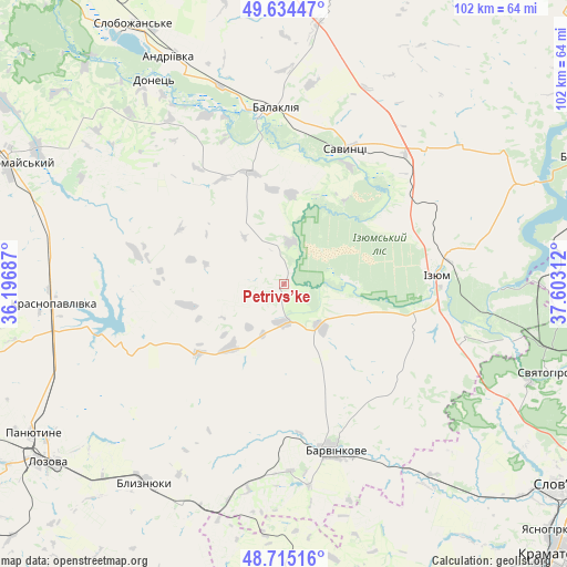
Petrivs’ke GPS coordinates[2]
49° 10' 37.02" North, 36° 53' 59.964" East
| Map corner | latitude | longitude |
|---|---|---|
| Upper-left | 49.63447°, | 36.19687° |
| Center: | 49.17695°, | 36.89999° |
| Lower-right: | 48.71516°, | 37.60312° |
| Map W x H: | 102.2×102.2 km | = 63.5×63.5mi |
| max Lat: | 52.18903° ⇑30.6% North |
| Petrivs’ke: | 49.17695° |
| min Lat: | ⇓69.4% South 44.39214° |
| min Long | Petrivs’ke | max Long |
| 22.20555° | 36.89999° | 40.13222° |
| W 90.7%⇐ | ⇒9.3% E |
Elevation
Elevation of Petrivs’ke is 97 m = 318 ft, and this is 58.8 m = 193 ft below average elevation for this country.
| Max E: |
886 m = 2907 ft | 63% |
| Avg. | 155.8 m = 511 ft | |
| Petrivs’ke | 97 m = 318 ft | |
Min E: |
-3 m = -10 ft | 37% |
See also: Ukraine elevation on elevation.city.
Geographical zone
Petrivs’ke is located in North temperate zone (between Tropic of Cancer and the Arctic Circle). Distance of this North polar circle is 1933.2 km =1201.2 mi to North.| Distance of | km | miles | from Petrivs’ke |
|---|---|---|---|
| North Pole | 4539.1 | 2820.5 | to North |
| Arctic Circle | 1933.2 | 1201.2 | to North |
| Tropic Cancer | 2862 | 1778.4 | to South |
| Equator | 5468 | 3397.7 | to South |


Nearby cities:
15 places around Petrivs’ke: (largest is in red/bold)
• Balakliya
31.9 km =19.8 mi,  354°
354°
• Barvinkove
31 km =19.3 mi,  163°
163°
• Blyznyuky
43.5 km =27 mi,  215°
215°
• Chervonyy Oskil
38.2 km =23.7 mi,  89°
89°
• Izyum
25.6 km =15.9 mi,  82°
82°
• Krasnopavlivka
42.5 km =26.4 mi,  263°
263°
• Lozova
53.2 km =33.1 mi,  233°
233°
• Oleksandrivka
52.1 km =32.4 mi,  178°
178°
• Panyutyne
52.7 km =32.7 mi,  239°
239°
• Pervomays’kyy
54.9 km =34.1 mi,  295°
295°
• Savyntsi
27.7 km =17.2 mi,  25°
25°
• Slobozhans’ke
54 km =33.6 mi,  329°
329°
• Studenok
43.8 km =27.2 mi,  102°
102°
• Svyatogorsk
51.1 km =31.8 mi,  108°
108°
• Yats’kivka
45.3 km =28.1 mi, 89°
Sources, notices
• [Note1] Compared only with cities in Ukraine existing in our database
• [Src1] Map data: © OpenStreetMap contributors (CC-BY-SA)
• [Src2] Other city data from geonames.org with taken over terms of usage.
• [Src3] Geographical zone / Annual Mean Temperature by Robert A. Rohde @ Wikipedia
