Pavlohrad geodata
Pavlohrad (Dnipropetrovsk) is a seat of a second-order administrative division; located in Ukraine in Europe/Kiev (GMT+3) time zone. With population of 115,932 people, there are 41 cities with bigger population in this country. Compared to other cities in Ukraine, 56.2% of cities are located further ↓South; 86.3% of cities are located further ←West and 71.8% of cities have higher elevation than Pavlohrad. Note1


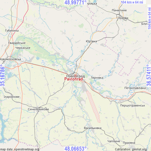
Pavlohrad GPS coordinates[2]
48° 32' 3.336" North, 35° 52' 15.528" East
| Map corner | latitude | longitude |
|---|---|---|
| Upper-left | 48.99771°, | 35.16786° |
| Center: | 48.53426°, | 35.87098° |
| Lower-right: | 48.06653°, | 36.57411° |
| Map W x H: | 103.5×103.5 km | = 64.3×64.3mi |
| max Lat: | 52.18903° ⇑43.8% North |
| Pavlohrad: | 48.53426° |
| min Lat: | ⇓56.2% South 44.39214° |
| min Long | Pavlohrad | max Long |
| 22.20555° | 35.87098° | 40.13222° |
| W 86.3%⇐ | ⇒13.7% E |
Elevation
Elevation of Pavlohrad is 70 m = 230 ft, and this is 85.8 m = 281 ft below average elevation for this country.
| Max E: |
886 m = 2907 ft | 71.8% |
| Avg. | 155.8 m = 511 ft | |
| Pavlohrad | 70 m = 230 ft | |
Min E: |
-3 m = -10 ft | 28.2% |
See also: Pavlohrad elevation on elevation.city.
Geographical zone
Pavlohrad is located in North temperate zone (between Tropic of Cancer and the Arctic Circle). Distance of this North polar circle is 2004.7 km =1245.7 mi to North.| Distance of | km | miles | from Pavlohrad |
|---|---|---|---|
| North Pole | 4610.6 | 2864.9 | to North |
| Arctic Circle | 2004.7 | 1245.7 | to North |
| Tropic Cancer | 2790.6 | 1734 | to South |
| Equator | 5396.5 | 3353.2 | to South |


Nearby cities:
15 places around Pavlohrad: (largest is in red/bold)
• Aviatorske
61.1 km =38 mi,  252°
252°
• Blyznyuky
61.8 km =38.4 mi,  54°
54°
• Hubynykha
54.6 km =33.9 mi,  304°
304°
• Kaydaki
57.8 km =35.9 mi, 252°
• Khashchevoye
43.2 km =26.8 mi, 295°
• Lozova
51.3 km =31.9 mi,  39°
39°
• Melioratyvne
35.2 km =21.9 mi,  287°
287°
• Novomoskovs’k
47.4 km =29.5 mi,  284°
284°
• Novomykolayivka
61.9 km =38.5 mi,  177°
177°
• Panyutyne
53.7 km =33.4 mi,  33°
33°
• Petropavlivka
42.6 km =26.5 mi,  101°
101°
• Pidhorodne
56.4 km =35 mi,  274°
274°
• Synel’nykove
35.3 km =21.9 mi,  227°
227°
• Vasyl’kivka
38.1 km =23.7 mi,  162°
162°
• Yur”yivka
25.1 km =15.6 mi, 25°
Sources, notices
• [Note1] Compared only with cities in Ukraine existing in our database
• [Src1] Map data: © OpenStreetMap contributors (CC-BY-SA)
• [Src2] Other city data from geonames.org with taken over terms of usage.
• [Src3] Geographical zone / Annual Mean Temperature by Robert A. Rohde @ Wikipedia
