Pervomays’kyy geodata
Pervomays’kyy (Kharkiv) is a seat of a second-order administrative division; located in Ukraine in Europe/Kiev (GMT+3) time zone. With population of 30,000 people, there are 142 cities with bigger population in this country. Compared to other cities in Ukraine, 72.5% of cities are located further ↓South; 88.2% of cities are located further ←West and 66.4% of cities have lower elevation than Pervomays’kyy. Note1


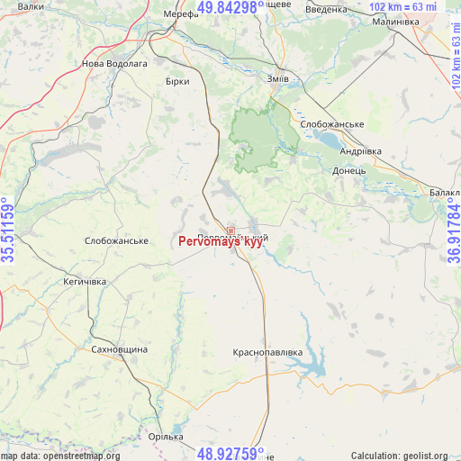
Pervomays’kyy GPS coordinates[2]
49° 23' 14.712" North, 36° 12' 52.956" East
| Map corner | latitude | longitude |
|---|---|---|
| Upper-left | 49.84298°, | 35.51159° |
| Center: | 49.38742°, | 36.21471° |
| Lower-right: | 48.92759°, | 36.91784° |
| Map W x H: | 101.8×101.8 km | = 63.3×63.3mi |
| max Lat: | 52.18903° ⇑27.5% North |
| Pervomays’kyy: | 49.38742° |
| min Lat: | ⇓72.5% South 44.39214° |
| min Long | Pervomays’kyy | max Long |
| 22.20555° | 36.21471° | 40.13222° |
| W 88.2%⇐ | ⇒11.8% E |
Elevation
Elevation of Pervomays’kyy is 191 m = 627 ft, and this is 35.2 m = 115 ft above average elevation for this country.
| Max E: |
886 m = 2907 ft | 33.6% |
| Pervomays’kyy | 191 m 627 ft | |
| Avg. | 155.8 m = 511 ft | |
Min E: |
-3 m = -10 ft | 66.4% |
See also: Ukraine elevation on elevation.city.
Geographical zone
Pervomays’kyy is located in North temperate zone (between Tropic of Cancer and the Arctic Circle). Distance of this North polar circle is 1909.8 km =1186.7 mi to North.| Distance of | km | miles | from Pervomays’kyy |
|---|---|---|---|
| North Pole | 4515.7 | 2805.9 | to North |
| Arctic Circle | 1909.8 | 1186.7 | to North |
| Tropic Cancer | 2885.4 | 1792.9 | to South |
| Equator | 5491.4 | 3412.2 | to South |


Nearby cities:
15 places around Pervomays’kyy: (largest is in red/bold)
• Balakliya
47.4 km =29.5 mi,  79°
79°
• Berezivka
37.2 km =23.1 mi,  278°
278°
• Chapayeve
24.7 km =15.3 mi,  264°
264°
• Kehychivka
34.7 km =21.6 mi,  251°
251°
• Krasnopavlivka
28.9 km =18 mi,  164°
164°
• Lyman
29.8 km =18.5 mi,  38°
38°
• Merefa
49.9 km =31 mi,  346°
346°
• Nova Vodolaha
44.6 km =27.7 mi,  325°
325°
• Sakhnovshchyna
36.1 km =22.4 mi,  223°
223°
• Slobozhans’ke
32.4 km =20.1 mi, 43°
• Tymchenky
19 km =11.8 mi,  196°
196°
• Utkivka
45.4 km =28.2 mi, 347°
• Vasyshcheve
49.7 km =30.9 mi,  9°
9°
• Verbivka
49.4 km =30.7 mi,  273°
273°
• Zmiyiv
33.3 km =20.7 mi,  16°
16°
Sources, notices
• [Note1] Compared only with cities in Ukraine existing in our database
• [Src1] Map data: © OpenStreetMap contributors (CC-BY-SA)
• [Src2] Other city data from geonames.org with taken over terms of usage.
• [Src3] Geographical zone / Annual Mean Temperature by Robert A. Rohde @ Wikipedia
