Oleksandriya geodata
Oleksandriya (Kirovohrad) is a seat of a second-order administrative division; located in Ukraine in Europe/Kiev (GMT+3) time zone. With population of 103,000 people, there are 45 cities with bigger population in this country. Compared to other cities in Ukraine, 59.6% of cities are located further ↓South; 52% of cities are located further →East and 59.9% of cities have higher elevation than Oleksandriya. Note1


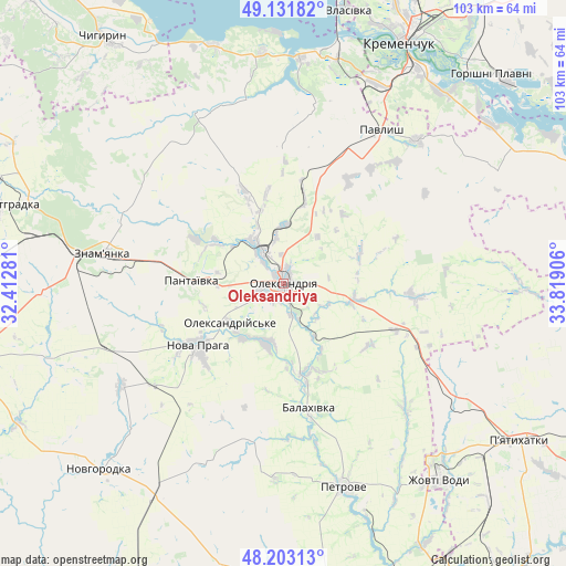
Oleksandriya GPS coordinates[2]
48° 40' 10.596" North, 33° 6' 57.348" East
| Map corner | latitude | longitude |
|---|---|---|
| Upper-left | 49.13182°, | 32.41281° |
| Center: | 48.66961°, | 33.11593° |
| Lower-right: | 48.20313°, | 33.81906° |
| Map W x H: | 103.3×103.3 km | = 64.2×64.2mi |
| max Lat: | 52.18903° ⇑40.4% North |
| Oleksandriya: | 48.66961° |
| min Lat: | ⇓59.6% South 44.39214° |
| min Long | Oleksandriya | max Long |
| 22.20555° | 33.11593° | 40.13222° |
| W 48%⇐ | ⇒52% E |
Elevation
Elevation of Oleksandriya is 106 m = 348 ft, and this is 49.8 m = 163 ft below average elevation for this country.
| Max E: |
886 m = 2907 ft | 59.9% |
| Avg. | 155.8 m = 511 ft | |
| Oleksandriya | 106 m = 348 ft | |
Min E: |
-3 m = -10 ft | 40.1% |
See also: Oleksandriya elevation on elevation.city.
Geographical zone
Oleksandriya is located in North temperate zone (between Tropic of Cancer and the Arctic Circle). Distance of this North polar circle is 1989.6 km =1236.3 mi to North.| Distance of | km | miles | from Oleksandriya |
|---|---|---|---|
| North Pole | 4595.5 | 2855.5 | to North |
| Arctic Circle | 1989.6 | 1236.3 | to North |
| Tropic Cancer | 2805.6 | 1743.3 | to South |
| Equator | 5411.6 | 3362.6 | to South |


Nearby cities:
15 places around Oleksandriya: (largest is in red/bold)
• Adzhamka
45 km =28 mi,  251°
251°
• Dmytrivka
32.5 km =20.2 mi,  295°
295°
• Kamennyye Potoki
45.7 km =28.4 mi,  41°
41°
• Nova Praha
19.3 km =12 mi,  234°
234°
• Novyy Starodub
17.6 km =10.9 mi,  166°
166°
• Oleksandriys’ke
11.9 km =7.4 mi, 234°
• Onufriyivka
35.9 km =22.3 mi, 42°
• Pantayivka
17 km =10.6 mi,  271°
271°
• Pavlysh
32.7 km =20.3 mi,  32°
32°
• Petrove
39.7 km =24.7 mi,  164°
164°
• Pryyutivka
6.6 km =4.1 mi,  329°
329°
• Subottsi
43.7 km =27.2 mi, 267°
• Svitlovods’k
43.2 km =26.8 mi,  12°
12°
• Zhovti Vody
46 km =28.6 mi,  141°
141°
• Znomenka
33.5 km =20.8 mi,  278°
278°
Sources, notices
• [Note1] Compared only with cities in Ukraine existing in our database
• [Src1] Map data: © OpenStreetMap contributors (CC-BY-SA)
• [Src2] Other city data from geonames.org with taken over terms of usage.
• [Src3] Geographical zone / Annual Mean Temperature by Robert A. Rohde @ Wikipedia
