Subottsi geodata
Subottsi (Kirovohrad) is a populated place; located in Ukraine in Europe/Kiev (GMT+3) time zone. With population of 3,095 people, there are 913 cities with bigger population in this country. Compared to other cities in Ukraine, 59.1% of cities are located further ↓South; 55.3% of cities are located further →East and 60.6% of cities have lower elevation than Subottsi. Note1


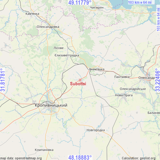
Subottsi GPS coordinates[2]
48° 39' 19.62" North, 32° 31' 15.348" East
| Map corner | latitude | longitude |
|---|---|---|
| Upper-left | 49.11779°, | 31.81781° |
| Center: | 48.65545°, | 32.52093° |
| Lower-right: | 48.18883°, | 33.22406° |
| Map W x H: | 103.3×103.3 km | = 64.2×64.2mi |
| max Lat: | 52.18903° ⇑40.9% North |
| Subottsi: | 48.65545° |
| min Lat: | ⇓59.1% South 44.39214° |
| min Long | Subottsi | max Long |
| 22.20555° | 32.52093° | 40.13222° |
| W 44.7%⇐ | ⇒55.3% E |
Elevation
Elevation of Subottsi is 170 m = 558 ft, and this is 14.2 m = 47 ft above average elevation for this country.
| Max E: |
886 m = 2907 ft | 39.4% |
| Subottsi | 170 m 558 ft | |
| Avg. | 155.8 m = 511 ft | |
Min E: |
-3 m = -10 ft | 60.6% |
See also: Ukraine elevation on elevation.city.
Geographical zone
Subottsi is located in North temperate zone (between Tropic of Cancer and the Arctic Circle). Distance of this North polar circle is 1991.2 km =1237.3 mi to North.| Distance of | km | miles | from Subottsi |
|---|---|---|---|
| North Pole | 4597.1 | 2856.5 | to North |
| Arctic Circle | 1991.2 | 1237.3 | to North |
| Tropic Cancer | 2804.1 | 1742.4 | to South |
| Equator | 5410 | 3361.6 | to South |


Nearby cities:
15 places around Subottsi: (largest is in red/bold)
• Adzhamka
12.6 km =7.8 mi,  175°
175°
• Chyhyryn
48.6 km =30.2 mi,  11°
11°
• Dmytrivka
21.3 km =13.2 mi,  42°
42°
• Kompaniyivka
50.5 km =31.4 mi,  207°
207°
• Kropyvnytskyi
24.9 km =15.5 mi,  230°
230°
• Nova Praha
29.7 km =18.5 mi,  109°
109°
• Novhorodka
33.8 km =21 mi,  162°
162°
• Novyy Starodub
50.4 km =31.3 mi, 107°
• Oleksandrivka
40.1 km =24.9 mi,  328°
328°
• Oleksandriya
43.7 km =27.2 mi,  87°
87°
• Oleksandriys’ke
34.4 km =21.4 mi,  98°
98°
• Pantayivka
26.7 km =16.6 mi, 85°
• Pryyutivka
41 km =25.5 mi,  79°
79°
• Yelyzavethradka
18.6 km =11.6 mi, 332°
• Znomenka
12.3 km =7.6 mi,  58°
58°
Sources, notices
• [Note1] Compared only with cities in Ukraine existing in our database
• [Src1] Map data: © OpenStreetMap contributors (CC-BY-SA)
• [Src2] Other city data from geonames.org with taken over terms of usage.
• [Src3] Geographical zone / Annual Mean Temperature by Robert A. Rohde @ Wikipedia
