Petrove geodata
Petrove (Kirovohrad) is a seat of a second-order administrative division; located in Ukraine in Europe/Kiev (GMT+3) time zone. With population of 8,252 people, there are 428 cities with bigger population in this country. Compared to other cities in Ukraine, 50.7% of cities are located further ↓South; 50.9% of cities are located further →East and 60.6% of cities have higher elevation than Petrove. Note1


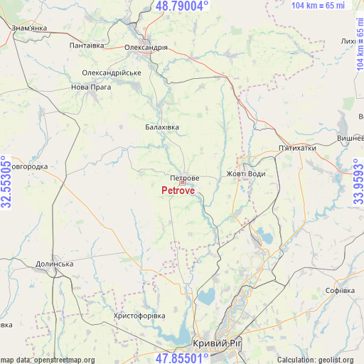
Petrove GPS coordinates[2]
48° 19' 28.812" North, 33° 15' 22.212" East
| Map corner | latitude | longitude |
|---|---|---|
| Upper-left | 48.79004°, | 32.55305° |
| Center: | 48.32467°, | 33.25617° |
| Lower-right: | 47.85501°, | 33.9593° |
| Map W x H: | 104×104 km | = 64.6×64.6mi |
| max Lat: | 52.18903° ⇑49.3% North |
| Petrove: | 48.32467° |
| min Lat: | ⇓50.7% South 44.39214° |
| min Long | Petrove | max Long |
| 22.20555° | 33.25617° | 40.13222° |
| W 49.1%⇐ | ⇒50.9% E |
Elevation
Elevation of Petrove is 104 m = 341 ft, and this is 51.8 m = 170 ft below average elevation for this country.
| Max E: |
886 m = 2907 ft | 60.6% |
| Avg. | 155.8 m = 511 ft | |
| Petrove | 104 m = 341 ft | |
Min E: |
-3 m = -10 ft | 39.4% |
See also: Ukraine elevation on elevation.city.
Geographical zone
Petrove is located in North temperate zone (between Tropic of Cancer and the Arctic Circle). Distance of this North polar circle is 2028 km =1260.1 mi to North.| Distance of | km | miles | from Petrove |
|---|---|---|---|
| North Pole | 4633.9 | 2879.4 | to North |
| Arctic Circle | 2028 | 1260.1 | to North |
| Tropic Cancer | 2767.3 | 1719.5 | to South |
| Equator | 5373.2 | 3338.8 | to South |


Nearby cities:
15 places around Petrove: (largest is in red/bold)
• Dolyns'ka
43.5 km =27 mi,  236°
236°
• Kryvyi Rih
47.1 km =29.3 mi,  168°
168°
• Lozuvatka
29.8 km =18.5 mi,  175°
175°
• Molodizhne
47.1 km =29.3 mi,  249°
249°
• Nova Praha
37.6 km =23.4 mi,  316°
316°
• Novhorodka
44.4 km =27.6 mi,  275°
275°
• Novyy Starodub
22.1 km =13.7 mi,  343°
343°
• Oleksandriya
39.7 km =24.7 mi, 344°
• Oleksandriys’ke
37.3 km =23.2 mi,  327°
327°
• Pantayivka
47.5 km =29.5 mi, 324°
• Piatykhatky
35 km =21.7 mi,  73°
73°
• Pryyutivka
46.1 km =28.6 mi, 342°
• Sofiyivka
55.3 km =34.4 mi,  123°
123°
• Vyshneve
50.2 km =31.2 mi,  75°
75°
• Zhovti Vody
18.4 km =11.4 mi, 82°
Sources, notices
• [Note1] Compared only with cities in Ukraine existing in our database
• [Src1] Map data: © OpenStreetMap contributors (CC-BY-SA)
• [Src2] Other city data from geonames.org with taken over terms of usage.
• [Src3] Geographical zone / Annual Mean Temperature by Robert A. Rohde @ Wikipedia
