Znomenka geodata
Znomenka (Kirovohrad) is a seat of a second-order administrative division; located in Ukraine in Europe/Kiev (GMT+3) time zone. With population of 28,318 people, there are 149 cities with bigger population in this country. Compared to other cities in Ukraine, 60.8% of cities are located further ↓South; 54.4% of cities are located further →East and 69.2% of cities have lower elevation than Znomenka. Note1


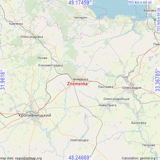
Znomenka GPS coordinates[2]
48° 42' 46.008" North, 32° 39' 52.992" East
| Map corner | latitude | longitude |
|---|---|---|
| Upper-left | 49.17459°, | 31.9616° |
| Center: | 48.71278°, | 32.66472° |
| Lower-right: | 48.24669°, | 33.36785° |
| Map W x H: | 103.2×103.2 km | = 64.1×64.1mi |
| max Lat: | 52.18903° ⇑39.2% North |
| Znomenka: | 48.71278° |
| min Lat: | ⇓60.8% South 44.39214° |
| min Long | Znomenka | max Long |
| 22.20555° | 32.66472° | 40.13222° |
| W 45.6%⇐ | ⇒54.4% E |
Elevation
Elevation of Znomenka is 202 m = 663 ft, and this is 46.2 m = 152 ft above average elevation for this country.
| Max E: |
886 m = 2907 ft | 30.8% |
| Znomenka | 202 m 663 ft | |
| Avg. | 155.8 m = 511 ft | |
Min E: |
-3 m = -10 ft | 69.2% |
See also: Ukraine elevation on elevation.city.
Geographical zone
Znomenka is located in North temperate zone (between Tropic of Cancer and the Arctic Circle). Distance of this North polar circle is 1984.8 km =1233.3 mi to North.| Distance of | km | miles | from Znomenka |
|---|---|---|---|
| North Pole | 4590.7 | 2852.5 | to North |
| Arctic Circle | 1984.8 | 1233.3 | to North |
| Tropic Cancer | 2810.4 | 1746.3 | to South |
| Equator | 5416.4 | 3365.6 | to South |


Nearby cities:
15 places around Znomenka: (largest is in red/bold)
• Adzhamka
21.2 km =13.2 mi,  206°
206°
• Chyhyryn
41.3 km =25.7 mi,  359°
359°
• Dmytrivka
10.1 km =6.3 mi,  22°
22°
• Kamianka
54.2 km =33.7 mi,  310°
310°
• Kropyvnytskyi
37.1 km =23.1 mi,  233°
233°
• Nova Praha
23.8 km =14.8 mi,  132°
132°
• Novhorodka
38.7 km =24 mi,  180°
180°
• Novyy Starodub
43.3 km =26.9 mi,  120°
120°
• Oleksandrivka
42 km =26.1 mi, 311°
• Oleksandriya
33.5 km =20.8 mi,  98°
98°
• Oleksandriys’ke
26.2 km =16.3 mi, 116°
• Pantayivka
16.7 km =10.4 mi, 104°
• Pryyutivka
29.8 km =18.5 mi,  88°
88°
• Subottsi
12.3 km =7.6 mi,  238°
238°
• Yelyzavethradka
21.6 km =13.4 mi,  297°
297°
Sources, notices
• [Note1] Compared only with cities in Ukraine existing in our database
• [Src1] Map data: © OpenStreetMap contributors (CC-BY-SA)
• [Src2] Other city data from geonames.org with taken over terms of usage.
• [Src3] Geographical zone / Annual Mean Temperature by Robert A. Rohde @ Wikipedia
