Turiys’k geodata
Turiys’k (Volyn) is a seat of a second-order administrative division; located in Ukraine in Europe/Kiev (GMT+3) time zone. In our database, there are 1661 cities with bigger population. Compared to other cities in Ukraine, 96.1% of cities are located further ↓South; 89.4% of cities are located further →East and 63.1% of cities have lower elevation than Turiys’k. Note1


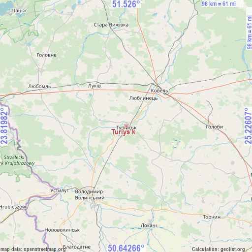
Turiys’k GPS coordinates[2]
51° 5' 11.184" North, 24° 31' 22.584" East
| Map corner | latitude | longitude |
|---|---|---|
| Upper-left | 51.526°, | 23.81982° |
| Center: | 51.08644°, | 24.52294° |
| Lower-right: | 50.64266°, | 25.22607° |
| Map W x H: | 98.2×98.2 km | = 61×61mi |
| max Lat: | 52.18903° ⇑3.9% North |
| Turiys’k: | 51.08644° |
| min Lat: | ⇓96.1% South 44.39214° |
| min Long | Turiys’k | max Long |
| 22.20555° | 24.52294° | 40.13222° |
| W 10.6%⇐ | ⇒89.4% E |
Elevation
Elevation of Turiys’k is 180 m = 591 ft, and this is 24.2 m = 79 ft above average elevation for this country.
| Max E: |
886 m = 2907 ft | 36.9% |
| Turiys’k | 180 m 591 ft | |
| Avg. | 155.8 m = 511 ft | |
Min E: |
-3 m = -10 ft | 63.1% |
See also: Ukraine elevation on elevation.city.
Geographical zone
Turiys’k is located in North temperate zone (between Tropic of Cancer and the Arctic Circle). Distance of this North polar circle is 1720.9 km =1069.3 mi to North.| Distance of | km | miles | from Turiys’k |
|---|---|---|---|
| North Pole | 4326.8 | 2688.5 | to North |
| Arctic Circle | 1720.9 | 1069.3 | to North |
| Tropic Cancer | 3074.4 | 1910.3 | to South |
| Equator | 5680.3 | 3529.6 | to South |


Nearby cities:
15 places around Turiys’k: (largest is in red/bold)
• Blahodatne
50.8 km =31.6 mi,  202°
202°
• Hołoby
33.9 km =21.1 mi,  89°
89°
• Ivanychi
51.1 km =31.8 mi,  192°
192°
• Kovel
19.3 km =12 mi,  42°
42°
• Liuboml
37.3 km =23.2 mi,  294°
294°
• Lokachi
39.9 km =24.8 mi,  167°
167°
• Lukiv
61.4 km =38.2 mi, 93°
• Novovolyns’k
47.4 km =29.5 mi,  212°
212°
• Nuyno
57.8 km =35.9 mi,  27°
27°
• Oles’k
23.4 km =14.5 mi,  276°
276°
• Pidrichchya
58.5 km =36.4 mi,  19°
19°
• Rozhyshche
55.6 km =34.5 mi,  110°
110°
• Shats’k
61.6 km =38.3 mi,  318°
318°
• Stara Vyzhivka
39.5 km =24.5 mi,  351°
351°
• Volodymyr-Volynskyi
29.5 km =18.3 mi, 208°
Sources, notices
• [Note1] Compared only with cities in Ukraine existing in our database
• [Src1] Map data: © OpenStreetMap contributors (CC-BY-SA)
• [Src2] Other city data from geonames.org with taken over terms of usage.
• [Src3] Geographical zone / Annual Mean Temperature by Robert A. Rohde @ Wikipedia
