Chervonyy Oskil geodata
Chervonyy Oskil (Kharkiv) is a populated place; located in Ukraine in Europe/Kiev (GMT+3) time zone. With population of 3,217 people, there are 884 cities with bigger population in this country. Compared to other cities in Ukraine, 69.5% of cities are located further ↓South; 92.2% of cities are located further ←West and 68% of cities have higher elevation than Chervonyy Oskil. Note1


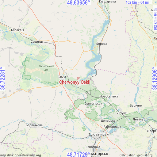
Chervonyy Oskil GPS coordinates[2]
49° 10' 44.616" North, 37° 25' 33.348" East
| Map corner | latitude | longitude |
|---|---|---|
| Upper-left | 49.63656°, | 36.72281° |
| Center: | 49.17906°, | 37.42593° |
| Lower-right: | 48.71729°, | 38.12906° |
| Map W x H: | 102.2×102.2 km | = 63.5×63.5mi |
| max Lat: | 52.18903° ⇑30.5% North |
| Chervonyy Oskil: | 49.17906° |
| min Lat: | ⇓69.5% South 44.39214° |
| min Long | Chervonyy Oskil | max Long |
| 22.20555° | 37.42593° | 40.13222° |
| W 92.2%⇐ | ⇒7.8% E |
Elevation
Elevation of Chervonyy Oskil is 81 m = 266 ft, and this is 74.8 m = 245 ft below average elevation for this country.
| Max E: |
886 m = 2907 ft | 68% |
| Avg. | 155.8 m = 511 ft | |
| Chervonyy Oskil | 81 m = 266 ft | |
Min E: |
-3 m = -10 ft | 32% |
See also: Ukraine elevation on elevation.city.
Geographical zone
Chervonyy Oskil is located in North temperate zone (between Tropic of Cancer and the Arctic Circle). Distance of this North polar circle is 1933 km =1201.1 mi to North.| Distance of | km | miles | from Chervonyy Oskil |
|---|---|---|---|
| North Pole | 4538.9 | 2820.3 | to North |
| Arctic Circle | 1933 | 1201.1 | to North |
| Tropic Cancer | 2862.3 | 1778.6 | to South |
| Equator | 5468.2 | 3397.8 | to South |


Nearby cities:
15 places around Chervonyy Oskil: (largest is in red/bold)
• Barvinkove
42.1 km =26.2 mi,  224°
224°
• Borova
26.2 km =16.3 mi,  32°
32°
• Drobysheve
26.9 km =16.7 mi,  124°
124°
• Izyum
13.3 km =8.3 mi,  284°
284°
• Lyman
34.6 km =21.5 mi,  127°
127°
• Novoselivka
23 km =14.3 mi, 121°
• Petrivs’ke
38.2 km =23.7 mi,  269°
269°
• Savyntsi
36.2 km =22.5 mi,  313°
313°
• Sloviansk
37.4 km =23.2 mi,  158°
158°
• Studenok
10.7 km =6.6 mi, 155°
• Svyatogorsk
19.2 km =11.9 mi,  147°
147°
• Terny
40.1 km =24.9 mi,  103°
103°
• Yampil’
47.2 km =29.3 mi, 125°
• Yats’kivka
7.1 km =4.4 mi,  89°
89°
• Zarichne
40.7 km =25.3 mi, 115°
Sources, notices
• [Note1] Compared only with cities in Ukraine existing in our database
• [Src1] Map data: © OpenStreetMap contributors (CC-BY-SA)
• [Src2] Other city data from geonames.org with taken over terms of usage.
• [Src3] Geographical zone / Annual Mean Temperature by Robert A. Rohde @ Wikipedia
