Borova geodata
Borova (Kharkiv) is a seat of a second-order administrative division; located in Ukraine in Europe/Kiev (GMT+3) time zone. With population of 6,589 people, there are 532 cities with bigger population in this country. Compared to other cities in Ukraine, 72.1% of cities are located further ↓South; 93% of cities are located further ←West and 65.4% of cities have higher elevation than Borova. Note1


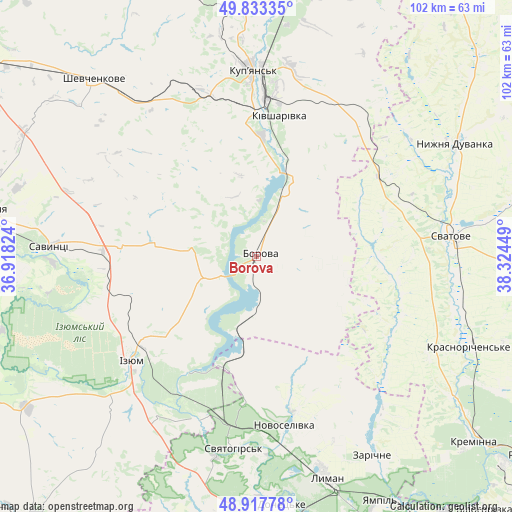
Borova GPS coordinates[2]
49° 22' 39.72" North, 37° 37' 16.896" East
| Map corner | latitude | longitude |
|---|---|---|
| Upper-left | 49.83335°, | 36.91824° |
| Center: | 49.3777°, | 37.62136° |
| Lower-right: | 48.91778°, | 38.32449° |
| Map W x H: | 101.8×101.8 km | = 63.3×63.3mi |
| max Lat: | 52.18903° ⇑27.9% North |
| Borova: | 49.3777° |
| min Lat: | ⇓72.1% South 44.39214° |
| min Long | Borova | max Long |
| 22.20555° | 37.62136° | 40.13222° |
| W 93%⇐ | ⇒7% E |
Elevation
Elevation of Borova is 88 m = 289 ft, and this is 67.8 m = 222 ft below average elevation for this country.
| Max E: |
886 m = 2907 ft | 65.4% |
| Avg. | 155.8 m = 511 ft | |
| Borova | 88 m = 289 ft | |
Min E: |
-3 m = -10 ft | 34.6% |
See also: Ukraine elevation on elevation.city.
Geographical zone
Borova is located in North temperate zone (between Tropic of Cancer and the Arctic Circle). Distance of this North polar circle is 1910.9 km =1187.4 mi to North.| Distance of | km | miles | from Borova |
|---|---|---|---|
| North Pole | 4516.8 | 2806.6 | to North |
| Arctic Circle | 1910.9 | 1187.4 | to North |
| Tropic Cancer | 2884.4 | 1792.3 | to South |
| Equator | 5490.3 | 3411.5 | to South |


Nearby cities:
15 places around Borova: (largest is in red/bold)
• Chervonyy Oskil
26.2 km =16.3 mi,  212°
212°
• Drobysheve
38.2 km =23.7 mi,  168°
168°
• Izyum
32.9 km =20.4 mi,  235°
235°
• Kivsharivka
28.6 km =17.8 mi,  9°
9°
• Kupjansk
37 km =23 mi,  359°
359°
• Lyman
45.2 km =28.1 mi,  163°
163°
• Novoselivka
34.6 km =21.5 mi, 171°
• Nyzhnya Duvanka
46.1 km =28.6 mi,  60°
60°
• Savyntsi
40.5 km =25.2 mi,  273°
273°
• Studenok
33.3 km =20.7 mi,  197°
197°
• Svatove
38.5 km =23.9 mi,  84°
84°
• Svyatogorsk
38.5 km =23.9 mi,  185°
185°
• Terny
40.2 km =25 mi,  142°
142°
• Yats’kivka
23.1 km =14.4 mi, 197°
• Zarichne
45.4 km =28.2 mi,  150°
150°
Sources, notices
• [Note1] Compared only with cities in Ukraine existing in our database
• [Src1] Map data: © OpenStreetMap contributors (CC-BY-SA)
• [Src2] Other city data from geonames.org with taken over terms of usage.
• [Src3] Geographical zone / Annual Mean Temperature by Robert A. Rohde @ Wikipedia
