Nikopol geodata
Nikopol (Dnipropetrovsk) is a seat of a second-order administrative division; located in Ukraine in Europe/Kiev (GMT+3) time zone. With population of 130,500 people, there are 35 cities with bigger population in this country. Compared to other cities in Ukraine, 60.1% of cities are located further ↑North; 72.1% of cities are located further ←West and 73.1% of cities have higher elevation than Nikopol. Note1


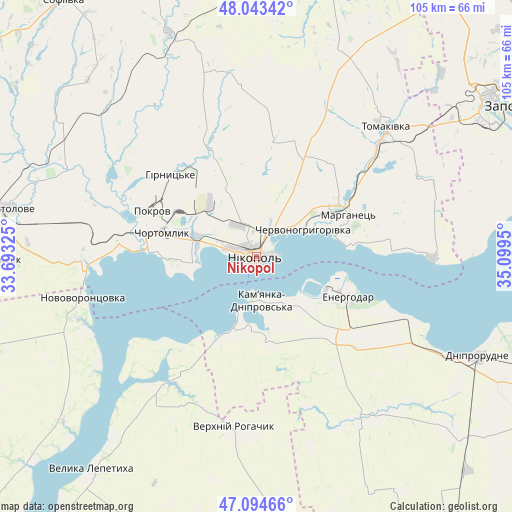
Nikopol GPS coordinates[2]
47° 34' 16.284" North, 34° 23' 46.932" East
| Map corner | latitude | longitude |
|---|---|---|
| Upper-left | 48.04342°, | 33.69325° |
| Center: | 47.57119°, | 34.39637° |
| Lower-right: | 47.09466°, | 35.0995° |
| Map W x H: | 105.5×105.5 km | = 65.6×65.6mi |
| max Lat: | 52.18903° ⇑60.1% North |
| Nikopol: | 47.57119° |
| min Lat: | ⇓39.9% South 44.39214° |
| min Long | Nikopol | max Long |
| 22.20555° | 34.39637° | 40.13222° |
| W 72.1%⇐ | ⇒27.9% E |
Elevation
Elevation of Nikopol is 67 m = 220 ft, and this is 88.8 m = 291 ft below average elevation for this country.
| Max E: |
886 m = 2907 ft | 73.1% |
| Avg. | 155.8 m = 511 ft | |
| Nikopol | 67 m = 220 ft | |
Min E: |
-3 m = -10 ft | 26.9% |
See also: Nikopol elevation on elevation.city.
Geographical zone
Nikopol is located in North temperate zone (between Tropic of Cancer and the Arctic Circle). Distance of this North polar circle is 2111.8 km =1312.2 mi to North.| Distance of | km | miles | from Nikopol |
|---|---|---|---|
| North Pole | 4717.6 | 2931.4 | to North |
| Arctic Circle | 2111.8 | 1312.2 | to North |
| Tropic Cancer | 2683.5 | 1667.4 | to South |
| Equator | 5289.4 | 3286.7 | to South |


Nearby cities:
15 places around Nikopol: (largest is in red/bold)
• Chervonohryhorivka
12.1 km =7.5 mi,  61°
61°
• Chortomlyk
19.9 km =12.4 mi,  286°
286°
• Dniprovka
22.9 km =14.2 mi,  133°
133°
• Energodar
21.2 km =13.2 mi,  112°
112°
• Kamenka-Na-Dnepre
9.7 km =6 mi,  173°
173°
• Marhanets’
18.8 km =11.7 mi,  67°
67°
• Novovorontsovka
36.8 km =22.9 mi,  257°
257°
• Ordzhonikidze
27.4 km =17 mi, 293°
• Sholokhove
30.6 km =19 mi,  296°
296°
• Tomakivka
37.5 km =23.3 mi,  43°
43°
• Velyka Bilozerka
40.1 km =24.9 mi,  144°
144°
• Verkhniy Rohachyk
35.9 km =22.3 mi,  187°
187°
• Vil’ne
32.1 km =19.9 mi,  76°
76°
• Vodyane
11.8 km =7.3 mi, 142°
• Vyshchetarasivka
36.4 km =22.6 mi,  90°
90°
Sources, notices
• [Note1] Compared only with cities in Ukraine existing in our database
• [Src1] Map data: © OpenStreetMap contributors (CC-BY-SA)
• [Src2] Other city data from geonames.org with taken over terms of usage.
• [Src3] Geographical zone / Annual Mean Temperature by Robert A. Rohde @ Wikipedia
