Chervonohryhorivka geodata
Chervonohryhorivka (Dnipropetrovsk) is a populated place; located in Ukraine in Europe/Kiev (GMT+3) time zone. With population of 6,444 people, there are 541 cities with bigger population in this country. Compared to other cities in Ukraine, 60% of cities are located further ↑North; 73.7% of cities are located further ←West and 87.6% of cities have higher elevation than Chervonohryhorivka. Note1


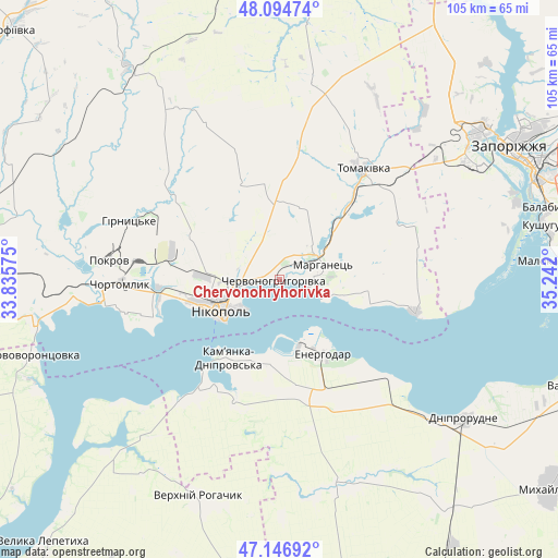
Chervonohryhorivka GPS coordinates[2]
47° 37' 22.728" North, 34° 32' 19.932" East
| Map corner | latitude | longitude |
|---|---|---|
| Upper-left | 48.09474°, | 33.83575° |
| Center: | 47.62298°, | 34.53887° |
| Lower-right: | 47.14692°, | 35.242° |
| Map W x H: | 105.4×105.4 km | = 65.5×65.5mi |
| max Lat: | 52.18903° ⇑60% North |
| Chervonohryhorivka: | 47.62298° |
| min Lat: | ⇓40% South 44.39214° |
| min Long | Chervonohryhori | max Long |
| 22.20555° | 34.53887° | 40.13222° |
| W 73.7%⇐ | ⇒26.3% E |
Elevation
Elevation of Chervonohryhorivka is 23 m = 75 ft, and this is 132.8 m = 436 ft below average elevation for this country.
| Max E: |
886 m = 2907 ft | 87.6% |
| Avg. | 155.8 m = 511 ft | |
| Chervonohryhorivka | 23 m = 75 ft | |
Min E: |
-3 m = -10 ft | 12.4% |
See also: Ukraine elevation on elevation.city.
Geographical zone
Chervonohryhorivka is located in North temperate zone (between Tropic of Cancer and the Arctic Circle). Distance of this North polar circle is 2106 km =1308.6 mi to North.| Distance of | km | miles | from Chervonohryhorivka |
|---|---|---|---|
| North Pole | 4711.9 | 2927.8 | to North |
| Arctic Circle | 2106 | 1308.6 | to North |
| Tropic Cancer | 2689.3 | 1671.1 | to South |
| Equator | 5295.2 | 3290.3 | to South |


Nearby cities:
15 places around Chervonohryhorivka: (largest is in red/bold)
• Balky
40.4 km =25.1 mi,  131°
131°
• Chortomlyk
29.7 km =18.5 mi,  270°
270°
• Dniprorudne
42.4 km =26.3 mi, 129°
• Dniprovka
22.3 km =13.9 mi,  164°
164°
• Energodar
16.4 km =10.2 mi,  147°
147°
• Kamenka-Na-Dnepre
18.1 km =11.2 mi,  211°
211°
• Marhanets’
6.8 km =4.2 mi,  78°
78°
• Nikopol
12.1 km =7.5 mi,  241°
241°
• Ordzhonikidze
36.2 km =22.5 mi,  277°
277°
• Sholokhove
38.8 km =24.1 mi, 281°
• Tomakivka
26.2 km =16.3 mi,  35°
35°
• Velyka Bilozerka
40.4 km =25.1 mi, 161°
• Vil’ne
20.7 km =12.9 mi,  85°
85°
• Vodyane
15.5 km =9.6 mi,  193°
193°
• Vyshchetarasivka
26.4 km =16.4 mi,  103°
103°
Sources, notices
• [Note1] Compared only with cities in Ukraine existing in our database
• [Src1] Map data: © OpenStreetMap contributors (CC-BY-SA)
• [Src2] Other city data from geonames.org with taken over terms of usage.
• [Src3] Geographical zone / Annual Mean Temperature by Robert A. Rohde @ Wikipedia
