Murovane geodata
Murovane (Lviv) is a populated place; located in Ukraine in Europe/Kiev (GMT+3) time zone. With population of 4,251 people, there are 730 cities with bigger population in this country. Compared to other cities in Ukraine, 74.6% of cities are located further ↓South; 98.4% of cities are located further →East and 92.5% of cities have lower elevation than Murovane. Note1


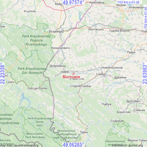
Murovane GPS coordinates[2]
49° 31' 17.148" North, 22° 56' 12.12" East
| Map corner | latitude | longitude |
|---|---|---|
| Upper-left | 49.97574°, | 22.23358° |
| Center: | 49.52143°, | 22.9367° |
| Lower-right: | 49.06285°, | 23.63983° |
| Map W x H: | 101.5×101.5 km | = 63.1×63.1mi |
| max Lat: | 52.18903° ⇑25.4% North |
| Murovane: | 49.52143° |
| min Lat: | ⇓74.6% South 44.39214° |
| min Long | Murovane | max Long |
| 22.20555° | 22.9367° | 40.13222° |
| W 1.6%⇐ | ⇒98.4% E |
Elevation
Elevation of Murovane is 326 m = 1070 ft, and this is 170.2 m = 558 ft above average elevation for this country.
| Max E: |
886 m = 2907 ft | 7.5% |
| Murovane | 326 m 1070 ft | |
| Avg. | 155.8 m = 511 ft | |
Min E: |
-3 m = -10 ft | 92.5% |
See also: Ukraine elevation on elevation.city.
Geographical zone
Murovane is located in North temperate zone (between Tropic of Cancer and the Arctic Circle). Distance of this North polar circle is 1894.9 km =1177.4 mi to North.| Distance of | km | miles | from Murovane |
|---|---|---|---|
| North Pole | 4500.8 | 2796.7 | to North |
| Arctic Circle | 1894.9 | 1177.4 | to North |
| Tropic Cancer | 2900.3 | 1802.2 | to South |
| Equator | 5506.3 | 3421.5 | to South |


Nearby cities:
15 places around Murovane: (largest is in red/bold)
• Dobromyl’
12.2 km =7.6 mi,  297°
297°
• Dublyany
32.6 km =20.3 mi,  94°
94°
• Khyriv
6 km =3.7 mi,  283°
283°
• Krukenychi
24.3 km =15.1 mi,  40°
40°
• Mostys'ka
34.1 km =21.2 mi,  26°
26°
• Pidbuzh
30.7 km =19.1 mi,  132°
132°
• Pnikut
25.6 km =15.9 mi, 34°
• Ralivka
21.8 km =13.5 mi,  96°
96°
• Rudky
42.3 km =26.3 mi,  69°
69°
• Sambir
18.8 km =11.7 mi, 91°
• Skelivka
2.7 km =1.7 mi,  48°
48°
• Staryy Sambir
10.3 km =6.4 mi,  153°
153°
• Turka
41.4 km =25.7 mi,  170°
170°
• Tvirzha
38 km =23.6 mi, 34°
• Voyutychi
12.6 km =7.8 mi, 74°
Sources, notices
• [Note1] Compared only with cities in Ukraine existing in our database
• [Src1] Map data: © OpenStreetMap contributors (CC-BY-SA)
• [Src2] Other city data from geonames.org with taken over terms of usage.
• [Src3] Geographical zone / Annual Mean Temperature by Robert A. Rohde @ Wikipedia
