Khyriv geodata
Khyriv (Lviv) is a populated place; located in Ukraine in Europe/Kiev (GMT+3) time zone. With population of 4,419 people, there are 711 cities with bigger population in this country. Compared to other cities in Ukraine, 75.2% of cities are located further ↓South; 98.6% of cities are located further →East and 93.2% of cities have lower elevation than Khyriv. Note1


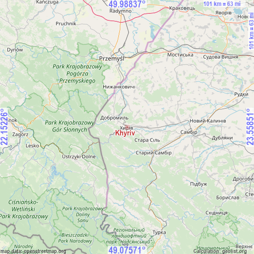
Khyriv GPS coordinates[2]
49° 32' 3.012" North, 22° 51' 19.368" East
| Map corner | latitude | longitude |
|---|---|---|
| Upper-left | 49.98837°, | 22.15226° |
| Center: | 49.53417°, | 22.85538° |
| Lower-right: | 49.07571°, | 23.55851° |
| Map W x H: | 101.5×101.5 km | = 63.1×63.1mi |
| max Lat: | 52.18903° ⇑24.8% North |
| Khyriv: | 49.53417° |
| min Lat: | ⇓75.2% South 44.39214° |
| min Long | Khyriv | max Long |
| 22.20555° | 22.85538° | 40.13222° |
| W 1.4%⇐ | ⇒98.6% E |
Elevation
Elevation of Khyriv is 334 m = 1096 ft, and this is 178.2 m = 585 ft above average elevation for this country.
| Max E: |
886 m = 2907 ft | 6.8% |
| Khyriv | 334 m 1096 ft | |
| Avg. | 155.8 m = 511 ft | |
Min E: |
-3 m = -10 ft | 93.2% |
See also: Ukraine elevation on elevation.city.
Geographical zone
Khyriv is located in North temperate zone (between Tropic of Cancer and the Arctic Circle). Distance of this North polar circle is 1893.5 km =1176.6 mi to North.| Distance of | km | miles | from Khyriv |
|---|---|---|---|
| North Pole | 4499.4 | 2795.8 | to North |
| Arctic Circle | 1893.5 | 1176.6 | to North |
| Tropic Cancer | 2901.8 | 1803.1 | to South |
| Equator | 5507.7 | 3422.3 | to South |


Nearby cities:
15 places around Khyriv: (largest is in red/bold)
• Dobromyl’
6.5 km =4 mi,  310°
310°
• Dublyany
38.6 km =24 mi,  95°
95°
• Krukenychi
27.6 km =17.1 mi,  51°
51°
• Mostys'ka
35.9 km =22.3 mi,  36°
36°
• Murovane
6 km =3.7 mi, 103°
• Pidbuzh
36.1 km =22.4 mi,  127°
127°
• Pnikut
28.3 km =17.6 mi, 46°
• Ralivka
27.8 km =17.3 mi, 97°
• Sambir
24.8 km =15.4 mi,  94°
94°
• Skelivka
7.9 km =4.9 mi, 87°
• Staryy Sambir
14.9 km =9.3 mi,  135°
135°
• Sudova Vyshnya
46.8 km =29.1 mi, 52°
• Turka
44.1 km =27.4 mi,  163°
163°
• Tvirzha
40.5 km =25.2 mi, 42°
• Voyutychi
18.2 km =11.3 mi,  83°
83°
Sources, notices
• [Note1] Compared only with cities in Ukraine existing in our database
• [Src1] Map data: © OpenStreetMap contributors (CC-BY-SA)
• [Src2] Other city data from geonames.org with taken over terms of usage.
• [Src3] Geographical zone / Annual Mean Temperature by Robert A. Rohde @ Wikipedia
