Mykhaylivka geodata
Mykhaylivka (Zaporizhia) is a seat of a second-order administrative division; located in Ukraine in Europe/Zaporozhye (GMT+3) time zone. With population of 13,216 people, there are 281 cities with bigger population in this country. Compared to other cities in Ukraine, 62.2% of cities are located further ↑North; 82.7% of cities are located further ←West and 66.9% of cities have higher elevation than Mykhaylivka. Note1


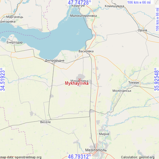
Mykhaylivka GPS coordinates[2]
47° 16' 20.46" North, 35° 13' 20.46" East
| Map corner | latitude | longitude |
|---|---|---|
| Upper-left | 47.74728°, | 34.51923° |
| Center: | 47.27235°, | 35.22235° |
| Lower-right: | 46.79312°, | 35.92548° |
| Map W x H: | 106.1×106.1 km | = 65.9×65.9mi |
| max Lat: | 52.18903° ⇑62.2% North |
| Mykhaylivka: | 47.27235° |
| min Lat: | ⇓37.8% South 44.39214° |
| min Long | Mykhaylivka | max Long |
| 22.20555° | 35.22235° | 40.13222° |
| W 82.7%⇐ | ⇒17.3% E |
Elevation
Elevation of Mykhaylivka is 84 m = 276 ft, and this is 71.8 m = 236 ft below average elevation for this country.
| Max E: |
886 m = 2907 ft | 66.9% |
| Avg. | 155.8 m = 511 ft | |
| Mykhaylivka | 84 m = 276 ft | |
Min E: |
-3 m = -10 ft | 33.1% |
See also: Ukraine elevation on elevation.city.
Geographical zone
Mykhaylivka is located in North temperate zone (between Tropic of Cancer and the Arctic Circle). Distance of this North polar circle is 2145 km =1332.8 mi to North.| Distance of | km | miles | from Mykhaylivka |
|---|---|---|---|
| North Pole | 4750.9 | 2952.1 | to North |
| Arctic Circle | 2145 | 1332.8 | to North |
| Tropic Cancer | 2650.3 | 1646.8 | to South |
| Equator | 5256.2 | 3266.1 | to South |


Nearby cities:
15 places around Mykhaylivka: (largest is in red/bold)
• Balky
24.3 km =15.1 mi,  300°
300°
• Dniprorudne
22.2 km =13.8 mi, 303°
• Mala Bilozerka
21.9 km =13.6 mi,  262°
262°
• Malokaterynivka
42.7 km =26.5 mi,  3°
3°
• Matviyivka
22.7 km =14.1 mi,  195°
195°
• Novobohdanivka
22.3 km =13.9 mi,  158°
158°
• Pryshyb
7.5 km =4.7 mi,  101°
101°
• Terpinnya
36.9 km =22.9 mi, 155°
• Tokmak
37 km =23 mi,  92°
92°
• Tymoshivka
12.7 km =7.9 mi,  219°
219°
• Vasylivka
18.7 km =11.6 mi,  12°
12°
• Velyka Bilozerka
38.9 km =24.2 mi,  270°
270°
• Vesele
36.9 km =22.9 mi, 219°
• Voznesenka
48.2 km =30 mi, 157°
• Vyshchetarasivka
41.8 km =26 mi,  322°
322°
Sources, notices
• [Note1] Compared only with cities in Ukraine existing in our database
• [Src1] Map data: © OpenStreetMap contributors (CC-BY-SA)
• [Src2] Other city data from geonames.org with taken over terms of usage.
• [Src3] Geographical zone / Annual Mean Temperature by Robert A. Rohde @ Wikipedia
