Balky geodata
Balky (Zaporizhia) is a populated place; located in Ukraine in Europe/Zaporozhye (GMT+3) time zone. With population of 5,717 people, there are 585 cities with bigger population in this country. Compared to other cities in Ukraine, 61.5% of cities are located further ↑North; 79.5% of cities are located further ←West and 70.6% of cities have higher elevation than Balky. Note1


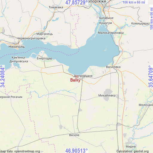
Balky GPS coordinates[2]
47° 23' 0.096" North, 34° 56' 38.256" East
| Map corner | latitude | longitude |
|---|---|---|
| Upper-left | 47.85729°, | 34.24084° |
| Center: | 47.38336°, | 34.94396° |
| Lower-right: | 46.90513°, | 35.64709° |
| Map W x H: | 105.9×105.9 km | = 65.8×65.8mi |
| max Lat: | 52.18903° ⇑61.5% North |
| Balky: | 47.38336° |
| min Lat: | ⇓38.5% South 44.39214° |
| min Long | Balky | max Long |
| 22.20555° | 34.94396° | 40.13222° |
| W 79.5%⇐ | ⇒20.5% E |
Elevation
Elevation of Balky is 73 m = 240 ft, and this is 82.8 m = 272 ft below average elevation for this country.
| Max E: |
886 m = 2907 ft | 70.6% |
| Avg. | 155.8 m = 511 ft | |
| Balky | 73 m = 240 ft | |
Min E: |
-3 m = -10 ft | 29.4% |
See also: Ukraine elevation on elevation.city.
Geographical zone
Balky is located in North temperate zone (between Tropic of Cancer and the Arctic Circle). Distance of this North polar circle is 2132.6 km =1325.1 mi to North.| Distance of | km | miles | from Balky |
|---|---|---|---|
| North Pole | 4738.5 | 2944.4 | to North |
| Arctic Circle | 2132.6 | 1325.1 | to North |
| Tropic Cancer | 2662.6 | 1654.5 | to South |
| Equator | 5268.5 | 3273.7 | to South |


Nearby cities:
15 places around Balky: (largest is in red/bold)
• Dniprorudne
2.5 km =1.6 mi,  94°
94°
• Dniprovka
25.1 km =15.6 mi,  281°
281°
• Energodar
25.1 km =15.6 mi,  300°
300°
• Mala Bilozerka
15.1 km =9.4 mi,  182°
182°
• Malokaterynivka
38.3 km =23.8 mi,  37°
37°
• Marhanets’
36.7 km =22.8 mi,  319°
319°
• Matviyivka
37.5 km =23.3 mi,  156°
156°
• Mykhaylivka
24.3 km =15.1 mi,  120°
120°
• Pryshyb
31.5 km =19.6 mi, 115°
• Tymoshivka
25.7 km =16 mi,  149°
149°
• Vasylivka
25.6 km =15.9 mi,  76°
76°
• Velyka Bilozerka
21.4 km =13.3 mi,  236°
236°
• Vil’ne
29.8 km =18.5 mi,  340°
340°
• Vodyane
35.9 km =22.3 mi,  288°
288°
• Vyshchetarasivka
21.1 km =13.1 mi,  347°
347°
Sources, notices
• [Note1] Compared only with cities in Ukraine existing in our database
• [Src1] Map data: © OpenStreetMap contributors (CC-BY-SA)
• [Src2] Other city data from geonames.org with taken over terms of usage.
• [Src3] Geographical zone / Annual Mean Temperature by Robert A. Rohde @ Wikipedia
