Malokaterynivka geodata
Malokaterynivka (Zaporizhia) is a populated place; located in Ukraine in Europe/Zaporozhye (GMT+3) time zone. With population of 3,174 people, there are 893 cities with bigger population in this country. Compared to other cities in Ukraine, 59.6% of cities are located further ↑North; 83.1% of cities are located further ←West and 77.6% of cities have higher elevation than Malokaterynivka. Note1


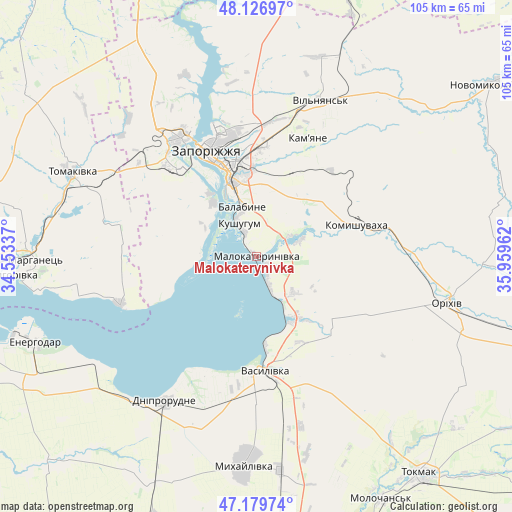
Malokaterynivka GPS coordinates[2]
47° 39' 19.8" North, 35° 15' 23.364" East
| Map corner | latitude | longitude |
|---|---|---|
| Upper-left | 48.12697°, | 34.55337° |
| Center: | 47.6555°, | 35.25649° |
| Lower-right: | 47.17974°, | 35.95962° |
| Map W x H: | 105.3×105.3 km | = 65.4×65.4mi |
| max Lat: | 52.18903° ⇑59.6% North |
| Malokaterynivka: | 47.6555° |
| min Lat: | ⇓40.4% South 44.39214° |
| min Long | Malokaterynivka | max Long |
| 22.20555° | 35.25649° | 40.13222° |
| W 83.1%⇐ | ⇒16.9% E |
Elevation
Elevation of Malokaterynivka is 52 m = 171 ft, and this is 103.8 m = 341 ft below average elevation for this country.
| Max E: |
886 m = 2907 ft | 77.6% |
| Avg. | 155.8 m = 511 ft | |
| Malokaterynivka | 52 m = 171 ft | |
Min E: |
-3 m = -10 ft | 22.4% |
See also: Ukraine elevation on elevation.city.
Geographical zone
Malokaterynivka is located in North temperate zone (between Tropic of Cancer and the Arctic Circle). Distance of this North polar circle is 2102.4 km =1306.4 mi to North.| Distance of | km | miles | from Malokaterynivka |
|---|---|---|---|
| North Pole | 4708.3 | 2925.6 | to North |
| Arctic Circle | 2102.4 | 1306.4 | to North |
| Tropic Cancer | 2692.9 | 1673.3 | to South |
| Equator | 5298.8 | 3292.5 | to South |


Nearby cities:
15 places around Malokaterynivka: (largest is in red/bold)
• Balky
38.3 km =23.8 mi,  217°
217°
• Dniprorudne
37 km =23 mi,  214°
214°
• Kirove
32.9 km =20.4 mi,  90°
90°
• Komyshuvakha
21.5 km =13.4 mi,  71°
71°
• Kushuhum
7.3 km =4.5 mi,  330°
330°
• Mykhaylivka
42.7 km =26.5 mi,  183°
183°
• Orikhiv
40.9 km =25.4 mi,  103°
103°
• Preobrazhenka
43 km =26.7 mi, 102°
• Pryshyb
44.3 km =27.5 mi,  173°
173°
• Tomakivka
42.4 km =26.3 mi,  294°
294°
• Vasylivka
24.3 km =15.1 mi, 176°
• Vil’ne
33.2 km =20.6 mi,  266°
266°
• Vil’nyans’k
34.7 km =21.6 mi,  22°
22°
• Vyshchetarasivka
29.8 km =18.5 mi,  251°
251°
• Zaporizhia
19.3 km =12 mi,  345°
345°
Sources, notices
• [Note1] Compared only with cities in Ukraine existing in our database
• [Src1] Map data: © OpenStreetMap contributors (CC-BY-SA)
• [Src2] Other city data from geonames.org with taken over terms of usage.
• [Src3] Geographical zone / Annual Mean Temperature by Robert A. Rohde @ Wikipedia
