Kovel geodata
Kovel (Volyn) is a seat of a second-order administrative division; located in Ukraine in Europe/Kiev (GMT+3) time zone. With population of 66,400 people, there are 71 cities with bigger population in this country. Compared to other cities in Ukraine, 96.8% of cities are located further ↓South; 87.9% of cities are located further →East and 61% of cities have lower elevation than Kovel. Note1


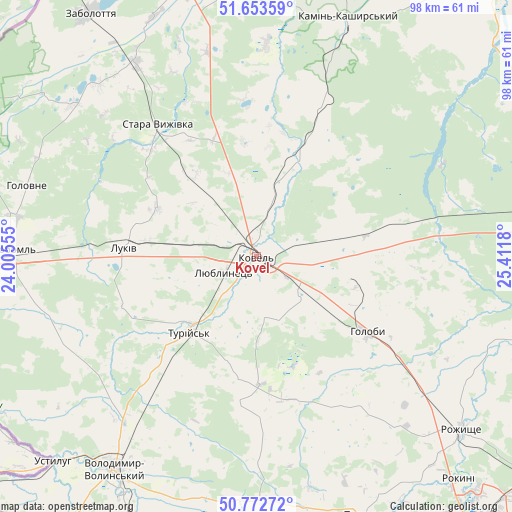
Kovel GPS coordinates[2]
51° 12' 54.936" North, 24° 42' 31.212" East
| Map corner | latitude | longitude |
|---|---|---|
| Upper-left | 51.65359°, | 24.00555° |
| Center: | 51.21526°, | 24.70867° |
| Lower-right: | 50.77272°, | 25.4118° |
| Map W x H: | 97.9×97.9 km | = 60.8×60.8mi |
| max Lat: | 52.18903° ⇑3.2% North |
| Kovel: | 51.21526° |
| min Lat: | ⇓96.8% South 44.39214° |
| min Long | Kovel | max Long |
| 22.20555° | 24.70867° | 40.13222° |
| W 12.1%⇐ | ⇒87.9% E |
Elevation
Elevation of Kovel is 172 m = 564 ft, and this is 16.2 m = 53 ft above average elevation for this country.
| Max E: |
886 m = 2907 ft | 39% |
| Kovel | 172 m 564 ft | |
| Avg. | 155.8 m = 511 ft | |
Min E: |
-3 m = -10 ft | 61% |
See also: Kovel elevation on elevation.city.
Geographical zone
Kovel is located in North temperate zone (between Tropic of Cancer and the Arctic Circle). Distance of this North polar circle is 1706.6 km =1060.4 mi to North.| Distance of | km | miles | from Kovel |
|---|---|---|---|
| North Pole | 4312.5 | 2679.7 | to North |
| Arctic Circle | 1706.6 | 1060.4 | to North |
| Tropic Cancer | 3088.7 | 1919.2 | to South |
| Equator | 5694.6 | 3538.5 | to South |


Nearby cities:
15 places around Kovel: (largest is in red/bold)
• Hołoby
25.3 km =15.7 mi,  124°
124°
• Kamin-Kashyrskyi
48.7 km =30.3 mi,  20°
20°
• Liuboml
46.8 km =29.1 mi,  271°
271°
• Lokachi
53.3 km =33.1 mi,  184°
184°
• Lukiv
51.6 km =32.1 mi,  110°
110°
• Manevychi
58.1 km =36.1 mi,  81°
81°
• Nuyno
39.4 km =24.5 mi, 20°
• Oles’k
38 km =23.6 mi,  252°
252°
• Pidrichchya
41.4 km =25.7 mi,  8°
8°
• Rakiv Lis
47.6 km =29.6 mi, 18°
• Ratne
51.9 km =32.2 mi,  346°
346°
• Rozhyshche
51.4 km =31.9 mi,  130°
130°
• Stara Vyzhivka
31 km =19.3 mi,  322°
322°
• Turiys’k
19.3 km =12 mi,  222°
222°
• Volodymyr-Volynskyi
48.5 km =30.1 mi,  213°
213°
Sources, notices
• [Note1] Compared only with cities in Ukraine existing in our database
• [Src1] Map data: © OpenStreetMap contributors (CC-BY-SA)
• [Src2] Other city data from geonames.org with taken over terms of usage.
• [Src3] Geographical zone / Annual Mean Temperature by Robert A. Rohde @ Wikipedia
