Luhansk geodata
Luhansk is a seat of a first-order administrative division; located in Ukraine in Europe/Zaporozhye (GMT+3) time zone. With population of 452,000 people, there are 10 cities with bigger population in this country. Compared to other cities in Ukraine, 57% of cities are located further ↓South; 99.1% of cities are located further ←West and 60.8% of cities have higher elevation than Luhansk. Note1


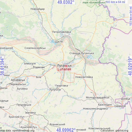
Luhansk GPS coordinates[2]
48° 34' 1.38" North, 39° 19' 1.416" East
| Map corner | latitude | longitude |
|---|---|---|
| Upper-left | 49.0302°, | 38.61394° |
| Center: | 48.56705°, | 39.31706° |
| Lower-right: | 48.09962°, | 40.02019° |
| Map W x H: | 103.5×103.5 km | = 64.3×64.3mi |
| max Lat: | 52.18903° ⇑43% North |
| Luhansk: | 48.56705° |
| min Lat: | ⇓57% South 44.39214° |
| min Long | Luhansk | max Long |
| 22.20555° | 39.31706° | 40.13222° |
| W 99.1%⇐ | ⇒0.90000000000001% E |
Elevation
Elevation of Luhansk is 103 m = 338 ft, and this is 52.8 m = 173 ft below average elevation for this country.
| Max E: |
886 m = 2907 ft | 60.8% |
| Avg. | 155.8 m = 511 ft | |
| Luhansk | 103 m = 338 ft | |
Min E: |
-3 m = -10 ft | 39.2% |
See also: Luhansk elevation on elevation.city.
Geographical zone
Luhansk is located in North temperate zone (between Tropic of Cancer and the Arctic Circle). Distance of this North polar circle is 2001 km =1243.4 mi to North.| Distance of | km | miles | from Luhansk |
|---|---|---|---|
| North Pole | 4606.9 | 2862.6 | to North |
| Arctic Circle | 2001 | 1243.4 | to North |
| Tropic Cancer | 2794.2 | 1736.2 | to South |
| Equator | 5400.1 | 3355.5 | to South |


Nearby cities:
15 places around Luhansk: (largest is in red/bold)
• Bile
21.2 km =13.2 mi,  247°
247°
• Buran
37 km =23 mi,  143°
143°
• Lenina
19.8 km =12.3 mi,  219°
219°
• Lutuhyne
19.2 km =11.9 mi,  200°
200°
• Makariv Yar
29.6 km =18.4 mi,  87°
87°
• Molodohvardiys’k
34.9 km =21.7 mi,  134°
134°
• Rozkishne
9.1 km =5.7 mi, 198°
• Shchastya
20.2 km =12.6 mi,  342°
342°
• Simeykyne
31.2 km =19.4 mi,  149°
149°
• Slov`yanoserbsk
28.6 km =17.8 mi,  300°
300°
• Stanytsya Luhans’ka
15.4 km =9.6 mi,  50°
50°
• Teple
33.6 km =20.9 mi, 147°
• Tr’okhizbenka
33.5 km =20.8 mi,  309°
309°
• Uspenka
22.7 km =14.1 mi,  210°
210°
• Zymohiria
28 km =17.4 mi,  274°
274°
Sources, notices
• [Note1] Compared only with cities in Ukraine existing in our database
• [Src1] Map data: © OpenStreetMap contributors (CC-BY-SA)
• [Src2] Other city data from geonames.org with taken over terms of usage.
• [Src3] Geographical zone / Annual Mean Temperature by Robert A. Rohde @ Wikipedia
