Uspenka geodata
Uspenka (Luhansk) is a populated place; located in Ukraine in Europe/Zaporozhye (GMT+3) time zone. With population of 9,400 people, there are 382 cities with bigger population in this country. Compared to other cities in Ukraine, 52.6% of cities are located further ↓South; 98.8% of cities are located further ←West and 64.3% of cities have higher elevation than Uspenka. Note1


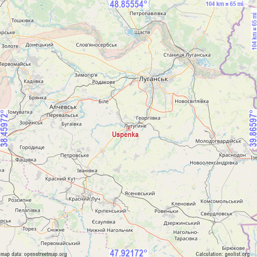
Uspenka GPS coordinates[2]
48° 23' 26.772" North, 39° 9' 46.224" East
| Map corner | latitude | longitude |
|---|---|---|
| Upper-left | 48.85554°, | 38.45972° |
| Center: | 48.39077°, | 39.16284° |
| Lower-right: | 47.92172°, | 39.86597° |
| Map W x H: | 103.8×103.8 km | = 64.5×64.5mi |
| max Lat: | 52.18903° ⇑47.4% North |
| Uspenka: | 48.39077° |
| min Lat: | ⇓52.6% South 44.39214° |
| min Long | Uspenka | max Long |
| 22.20555° | 39.16284° | 40.13222° |
| W 98.8%⇐ | ⇒1.2% E |
Elevation
Elevation of Uspenka is 93 m = 305 ft, and this is 62.8 m = 206 ft below average elevation for this country.
| Max E: |
886 m = 2907 ft | 64.3% |
| Avg. | 155.8 m = 511 ft | |
| Uspenka | 93 m = 305 ft | |
Min E: |
-3 m = -10 ft | 35.7% |
See also: Ukraine elevation on elevation.city.
Geographical zone
Uspenka is located in North temperate zone (between Tropic of Cancer and the Arctic Circle). Distance of this North polar circle is 2020.6 km =1255.5 mi to North.| Distance of | km | miles | from Uspenka |
|---|---|---|---|
| North Pole | 4626.5 | 2874.8 | to North |
| Arctic Circle | 2020.6 | 1255.5 | to North |
| Tropic Cancer | 2774.6 | 1724.1 | to South |
| Equator | 5380.5 | 3343.3 | to South |


Nearby cities:
15 places around Uspenka: (largest is in red/bold)
• Alchevs’k
27 km =16.8 mi,  288°
288°
• Antratsyt
31.1 km =19.3 mi,  189°
189°
• Artemivs’k
32.3 km =20.1 mi,  279°
279°
• Bile
14.3 km =8.9 mi,  324°
324°
• Krasnyy Kut
34.3 km =21.3 mi,  232°
232°
• Krasnyy Luch
32.5 km =20.2 mi,  210°
210°
• Lenina
4.5 km =2.8 mi,  343°
343°
• Luhansk
22.7 km =14.1 mi,  30°
30°
• Lutuhyne
5 km =3.1 mi,  71°
71°
• Millerovo
24.7 km =15.3 mi,  179°
179°
• Pereval’s’k
24.1 km =15 mi, 282°
• Rozkishne
13.9 km =8.6 mi,  37°
37°
• Simeykyne
28.3 km =17.6 mi,  104°
104°
• Teple
30.8 km =19.1 mi,  106°
106°
• Zymohiria
27.3 km =17 mi, 322°
Sources, notices
• [Note1] Compared only with cities in Ukraine existing in our database
• [Src1] Map data: © OpenStreetMap contributors (CC-BY-SA)
• [Src2] Other city data from geonames.org with taken over terms of usage.
• [Src3] Geographical zone / Annual Mean Temperature by Robert A. Rohde @ Wikipedia
